December 6, 2007
Highlights
- Values to 0.35% U308 in outcrop and 0.73% U308 in boulders
- Submission of 2008 work plans for Mount Benedict LIL and LISA lands
- Winter drilling planned to test T-649 and Super 7 showings
- Significant values to 0.7 % U308 located on the Makkovik River property
December 6, 2007 - Bridgewater, NS - Silver Spruce Resources Inc. (TSXV: SSE) is pleased to provide an update on exploration work on its Makkovik River and Mount Benedict properties, in the eastern portion of the Central Mineral Belt (CMB) of Labrador. Both properties are 100-percent owned by Silver Spruce.
Mount Benedict Property
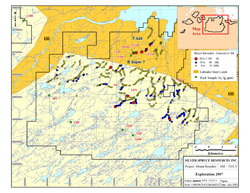
Work on the Mount Benedict property during 2007 consisted of prospecting airborne radiometric anomalies located in the 2006 survey, and regional stream sediment sampling surveys. Prospecting in the summer led to the discovery of two significant high-grade uranium prospects -- the T-649, where five grab samples averaged 0.5% (10 lbs/ton) U308 and boulders with values to over 3% (60 lbs/ton) U308 were located; and the Super 7, with values to over 1.0% (20 lbs/ton) U308 -- both located on LIL (Labrador Inuit) lands. An archeological assessment for the area has been completed and submitted to the Nunatsiavut government and a work proposal to drill test both prospects in the first quarter of 2008 has been submitted to both the Nunatsiavut and Newfoundland and Labrador governments.
A regional silt sampling survey initiated in mid-September covered the northern portion of the property, on LISA (Labrador Inuit Settlement Area) lands, using the town of Makkovik as a base. Approximately 500 stream sediment samples were taken prior to the onset of winter conditions. Results were positive, with a number of areas giving first order, coincident U/Cu/Pb/Mo anomalies with uranium values greater than 60 ppm (against a background of <10 ppm). Uranium mineralization was also located in bedrock, with one value of 0.35% U308; and in float boulders, with values from 0.026% to 0.25% U308. Analytical results for stream sediment samples collected from drainages proximal to the T-649 and Super 7 showings are similarly anomalous in U/Cu/Pb/Mo. No follow up has been carried out. Results are shown on the compilation map below.
2008 Work plans for the Mount Benedict property on LISA lands have been submitted to both the Nunatsiavut and Newfoundland and Labrador governments. Work planned consists of airborne radiometric/magnetic surveys, prospecting, stream sediment and soil geochemistry, geological surveys, RadonEx and scintillometer ground surveys followed by drilling.
Makkovik River
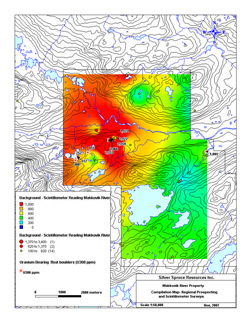
Prospecting surveys, in conjunction with stream sediment sampling, were carried out in late August and early September, prior to an airborne radiometric/magnetic survey which was flown in late September. Uranium-bearing boulders were located along a northeast trending zone, approximately 1,500 to 2,000 meters in length. Mineralization is hosted in sheared /hematitized extrusive and intrusive rocks with float samples giving values from 0.049% to 0.733% U308. Scintillometer readings were taken along traverse lines where bedrock was exposed or in areas where mineralized boulders were located. The results are shown on the compilation map below, with the shading based on the scintillometer values. No follow up has been carried out. The airborne survey results are pending.
Detailed follow up work, consisting of prospecting, geochemical, geophysical and geological ground surveys, followed by trenching and drilling, if warranted, will be carried out in 2008.
ABOUT THE MOUNT BENEDICT AND MAKKOVIK PROPERTIES
The Mount Benedict Property is a large contiguous block of 3,695 claims (924 square kilometers), located 30 kilometers southeast of Makkovik. It is located in part, (15 percent), on Labrador Inuit Land (LIL), which is controlled by the Nunatsiavut Government. The remaining 85 percent is on Labrador Inuit Settlement Area (LISA) lands, which are jointly controlled by the Nunatsiavut and the Newfoundland Government. The claims are 100-percent owned by Silver Spruce, subject to a one percent NSR payable on production from 532 of the claims.
The Makkovik River Property consists of 200 claims (50 square kilometers), located 30 kilometers to the east of Postville on Labrador Inuit Settlement Area (LISA) lands. The claims are owned 100 percent by Silver Spruce.
ABOUT SILVER SPRUCE
Silver Spruce Resources Inc. (TSXV: SSE) is a junior exploration company primarily focused on uranium in the Central Mineral Belt (CMB) of Labrador, Canada. With interests in more than 13,100 claims totaling approximately 3,275 square kilometers in Labrador, Silver Spruce is the second largest landholder in one of the world's premier emerging uranium districts. Experienced partners and strong financial backing make Silver Spruce a leading uranium explorer in Canada.
This release has been approved by Peter Dimmell, P.Geo., Vice President of Exploration, Silver Spruce Resources Inc., who is a Qualified Person (QP) as defined in National Instrument 43-101.
Click to enlarge
Click to enlarge
For Further Information Contact:
SILVER SPRUCE RESOURCES
HEAD OFFICE
Gordon Barnhill, CFO & Director
Phone: 902.527.5700
Fax: 902.527.5711
E-mail: gbarnhill@silverspruceresources.com
Web: www.silverspruceresources.com
INVESTOR RELATIONS
Keir Reynolds, Ascenta Capital Partners Inc.
Phone: 604.684.4743 ext. 231
Toll Free: 1.866.684.4743 ext. 231
E-mail: keir@ascentacapital.com
Web: www.ascentacapital.com
The TSX Venture Exchange does not accept responsibility for the adequacy or accuracy of this release. The company seeks Safe Harbour.
- Values to 0.35% U308 in outcrop and 0.73% U308 in boulders
- Submission of 2008 work plans for Mount Benedict LIL and LISA lands
- Winter drilling planned to test T-649 and Super 7 showings
- Significant values to 0.7 % U308 located on the Makkovik River property
December 6, 2007 - Bridgewater, NS - Silver Spruce Resources Inc. (TSXV: SSE) is pleased to provide an update on exploration work on its Makkovik River and Mount Benedict properties, in the eastern portion of the Central Mineral Belt (CMB) of Labrador. Both properties are 100-percent owned by Silver Spruce.
Mount Benedict Property
Work on the Mount Benedict property during 2007 consisted of prospecting airborne radiometric anomalies located in the 2006 survey, and regional stream sediment sampling surveys. Prospecting in the summer led to the discovery of two significant high-grade uranium prospects -- the T-649, where five grab samples averaged 0.5% (10 lbs/ton) U308 and boulders with values to over 3% (60 lbs/ton) U308 were located; and the Super 7, with values to over 1.0% (20 lbs/ton) U308 -- both located on LIL (Labrador Inuit) lands. An archeological assessment for the area has been completed and submitted to the Nunatsiavut government and a work proposal to drill test both prospects in the first quarter of 2008 has been submitted to both the Nunatsiavut and Newfoundland and Labrador governments.
A regional silt sampling survey initiated in mid-September covered the northern portion of the property, on LISA (Labrador Inuit Settlement Area) lands, using the town of Makkovik as a base. Approximately 500 stream sediment samples were taken prior to the onset of winter conditions. Results were positive, with a number of areas giving first order, coincident U/Cu/Pb/Mo anomalies with uranium values greater than 60 ppm (against a background of <10 ppm). Uranium mineralization was also located in bedrock, with one value of 0.35% U308; and in float boulders, with values from 0.026% to 0.25% U308. Analytical results for stream sediment samples collected from drainages proximal to the T-649 and Super 7 showings are similarly anomalous in U/Cu/Pb/Mo. No follow up has been carried out. Results are shown on the compilation map below.
2008 Work plans for the Mount Benedict property on LISA lands have been submitted to both the Nunatsiavut and Newfoundland and Labrador governments. Work planned consists of airborne radiometric/magnetic surveys, prospecting, stream sediment and soil geochemistry, geological surveys, RadonEx and scintillometer ground surveys followed by drilling.
Makkovik River
Prospecting surveys, in conjunction with stream sediment sampling, were carried out in late August and early September, prior to an airborne radiometric/magnetic survey which was flown in late September. Uranium-bearing boulders were located along a northeast trending zone, approximately 1,500 to 2,000 meters in length. Mineralization is hosted in sheared /hematitized extrusive and intrusive rocks with float samples giving values from 0.049% to 0.733% U308. Scintillometer readings were taken along traverse lines where bedrock was exposed or in areas where mineralized boulders were located. The results are shown on the compilation map below, with the shading based on the scintillometer values. No follow up has been carried out. The airborne survey results are pending.
Detailed follow up work, consisting of prospecting, geochemical, geophysical and geological ground surveys, followed by trenching and drilling, if warranted, will be carried out in 2008.
ABOUT THE MOUNT BENEDICT AND MAKKOVIK PROPERTIES
The Mount Benedict Property is a large contiguous block of 3,695 claims (924 square kilometers), located 30 kilometers southeast of Makkovik. It is located in part, (15 percent), on Labrador Inuit Land (LIL), which is controlled by the Nunatsiavut Government. The remaining 85 percent is on Labrador Inuit Settlement Area (LISA) lands, which are jointly controlled by the Nunatsiavut and the Newfoundland Government. The claims are 100-percent owned by Silver Spruce, subject to a one percent NSR payable on production from 532 of the claims.
The Makkovik River Property consists of 200 claims (50 square kilometers), located 30 kilometers to the east of Postville on Labrador Inuit Settlement Area (LISA) lands. The claims are owned 100 percent by Silver Spruce.
ABOUT SILVER SPRUCE
Silver Spruce Resources Inc. (TSXV: SSE) is a junior exploration company primarily focused on uranium in the Central Mineral Belt (CMB) of Labrador, Canada. With interests in more than 13,100 claims totaling approximately 3,275 square kilometers in Labrador, Silver Spruce is the second largest landholder in one of the world's premier emerging uranium districts. Experienced partners and strong financial backing make Silver Spruce a leading uranium explorer in Canada.
This release has been approved by Peter Dimmell, P.Geo., Vice President of Exploration, Silver Spruce Resources Inc., who is a Qualified Person (QP) as defined in National Instrument 43-101.
Click to enlarge
Click to enlarge
For Further Information Contact:
SILVER SPRUCE RESOURCES
HEAD OFFICE
Gordon Barnhill, CFO & Director
Phone: 902.527.5700
Fax: 902.527.5711
E-mail: gbarnhill@silverspruceresources.com
Web: www.silverspruceresources.com
INVESTOR RELATIONS
Keir Reynolds, Ascenta Capital Partners Inc.
Phone: 604.684.4743 ext. 231
Toll Free: 1.866.684.4743 ext. 231
E-mail: keir@ascentacapital.com
Web: www.ascentacapital.com
The TSX Venture Exchange does not accept responsibility for the adequacy or accuracy of this release. The company seeks Safe Harbour.