February 26, 2008
Highlights:
- Permit received for drilling on Mount Benedict Property, T-649 and Super 7 showings
- Three high priority and eight moderate priority airborne targets on the Makkovik River Property
Bridgewater, NS / Vancouver, BC - Silver Spruce Resources Inc. (TSXV: SSE) is pleased to announce that permits have been received from the Nunatsiavut Government for the planned diamond drilling on the Mount Benedict property, T-649 and Super Seven showings, in the eastern part of the Central Mineral Belt (CMB) of Labrador. In addition, results from the airborne radiometric/magnetic surveys carried out over the Makkovik River property in the fall of 2007, by McPhar Geosurveys Ltd., indicate significant uranium anomalies that will require follow up. Both properties are 100% owned by Silver Spruce with 532 original claims in the Mount Benedict property subject to a 1.0% NSR.
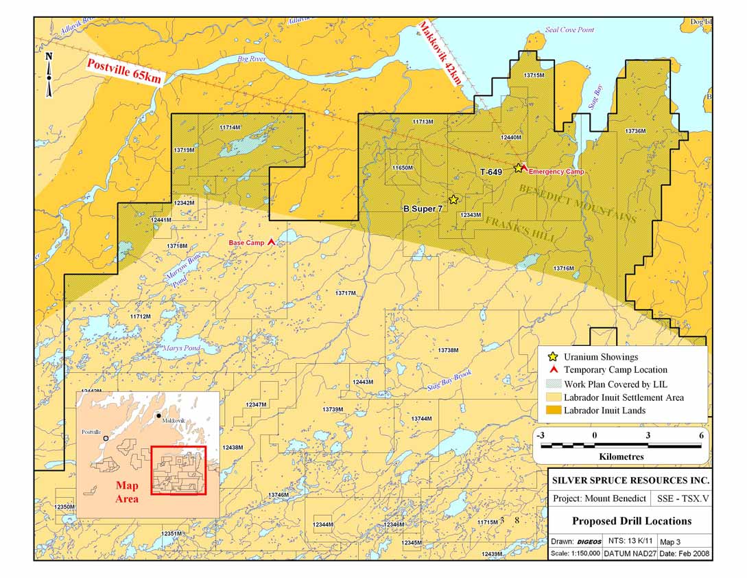
Mount Benedict Property
The permit for the pre-drilling work and diamond drilling for the T-649 and Super Seven showings, and the summer work program on the Mount Benedict Property, was received on February 22. The permit requires a public information session to be held in Makkovik at least two weeks prior to the start of the program and this is in the planning stages. A fully winterized camp has been established on a small lake approximately 50 kilometers to the south of Makkovik on Labrador Inuit Settlement Area (LISA) lands. The T-649 and Super Seven showings, located in the summer of 2007 during prospecting follow up of airborne surveys, are high-grade uranium prospects. At the T-649, five grab samples taken across a 12 to 14 meter wide outcrop of hematite breccia, averaged 0.5% (10 lbs/ton) U3O8 and boulders with values over 3.0% (60 lbs/ton) U3O8 were located downstream of the showing. Values varying from a few hundred ppm to 1.0% (20 lbs/ton) U3O8 were located at the Super 7 prospect in limited sampling. The drilling, which is helicopter supported, is planned to start around mid March once all gear has been mobilized to the area, and all requirements under the permit, including the hiring of an environmental monitor, have been met.
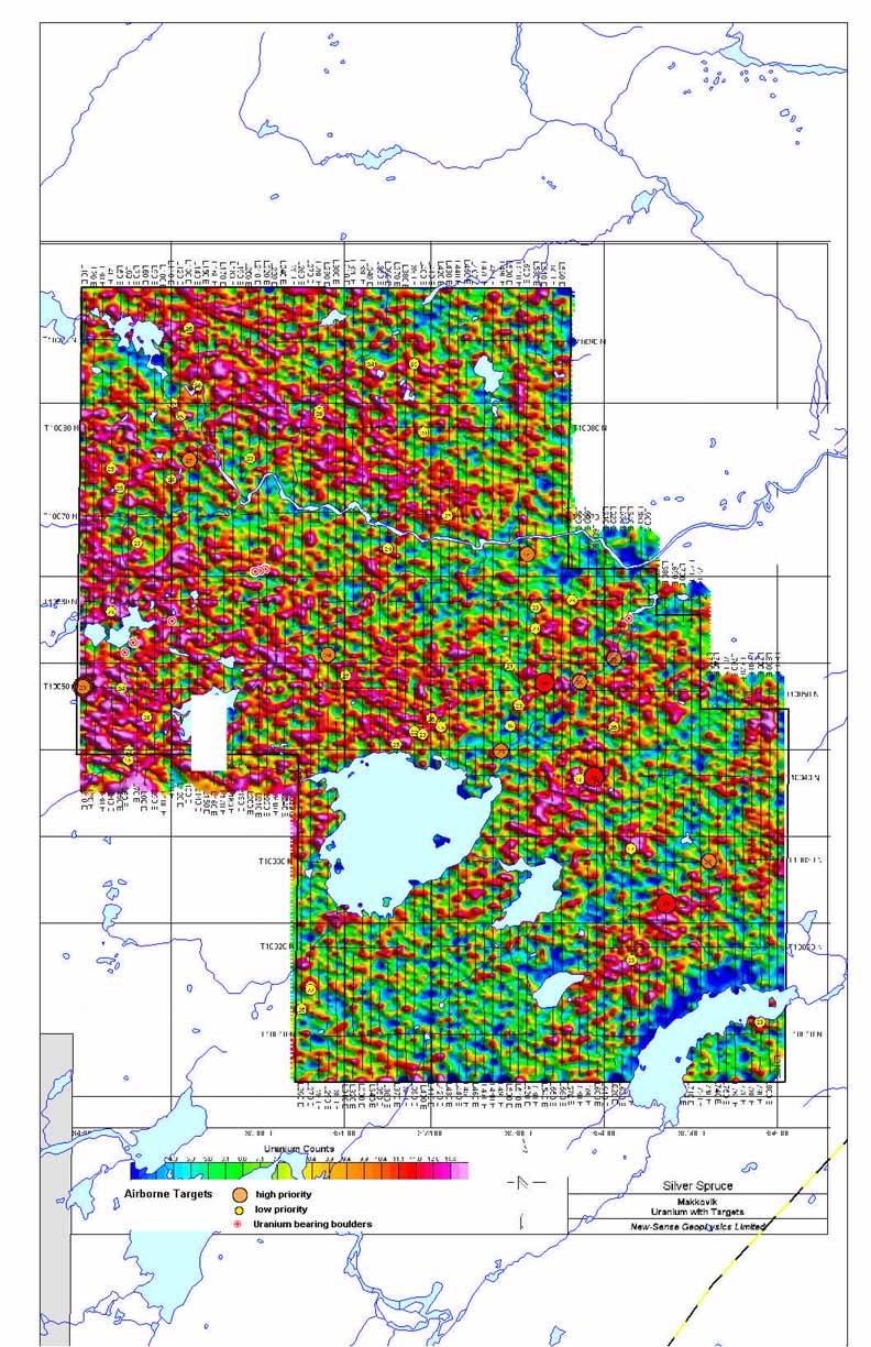
Makkovik River Property
A 560.5 line kilometer airborne radiometric/magnetic survey was flown in a north-south direction at 100-meter line spacing by McPhar Geosurveys Ltd. in September 2007. Three high-priority, eight moderate-priority and a number of lower priority targets were "picked" by consultant, Ted Urquhart of NuSense Geophysics (Santiago, Chile). They were selected on the basis of U/Th ratios, using the 95th percentile with a minimum of 14 cps uranium, total uranium and total field magnetics.
Prospecting surveys carried out in late August and early September of 2007, prior to the airborne survey, located uranium-bearing boulders along a northeast trending zone, approximately 1,500 to 2,000 meters in length in the west central part of the property. Mineralization is hosted in sheared/hematitized extrusive and intrusive rocks with float samples giving values from 0.049% to 0.733% U3O8. Some coincidence with the airborne target picks is noted.
No follow up has been carried out. Detailed follow up work, consisting of prospecting, geochemical, geophysical and geological ground surveys, followed by trenching and drilling, if warranted, will be carried out in the summer of 2008.
Results for the 2007 prospecting surveys and the uranium airborne picks on the Makkovik River property and maps showing the planned drilling on the Mount Benedict property are on the company's website (www.silverspruceresources.com).
About the Mount Benedict and Makkovik River Properties
The Mount Benedict Property is a large contiguous block of 4,057 claims (1,014 square kilometers), located 30 to 70 kilometers southeast of Makkovik. It is located in part, (10% to 15%), on Labrador Inuit Land (LIL), which is controlled by the Nunatsiavut Government. The remaining 85% is on Labrador Inuit Settlement Area (LISA) lands, which are jointly controlled by the Nunatsiavut and the Newfoundland Government. The claims are 100% owned by Silver Spruce, subject to a 1.0% NSR payable on production from 532 of the original 1,024 claims.
The Makkovik River property, consisting of 200 claims (50 square kilometers), is located in the eastern part of the Central Mineral Belt, 30 kilometers to the east of Postville, on Labrador Inuit Settlement Area (LISA) lands. It was acquired by staking in 2007 and is owned 100% by Silver Spruce.
ABOUT SILVER SPRUCE
Silver Spruce Resources Inc. (TSXV: SSE) is a junior exploration company primarily focused on uranium in the Central Mineral Belt (CMB) of Labrador, Canada. With interests in more than 12,500 claims totaling approximately 3,125 square kilometers in Labrador, and 60% of these 100%-owned, Silver Spruce is the second largest landholder in one of the world's premier emerging uranium districts. A good property position and strong financial backing makes Silver Spruce a leading uranium explorer in Newfoundland and Labrador and in Canada.
For Further Information Contact:
SILVER SPRUCE RESOURCES
HEAD OFFICE
Gordon Barnhill, CFO & Director
Phone: 902.527.5700
Fax: 902.527.5711
E-mail: gbarnhill@silverspruceresources.com
Web: www.silverspruceresources.com
INVESTOR RELATIONS
Hugh Oswald, Ascenta Capital Partners Inc.
Phone: 604.684.4743 ext. 243
Toll Free: 1.866.684.4743 ext. 243
E-mail: hugh@ascentacapital.com
Web: www.ascentacapital.com
The TSX Venture Exchange does not accept responsibility for the adequacy or accuracy of this release. The company seeks Safe Harbour.
- Permit received for drilling on Mount Benedict Property, T-649 and Super 7 showings
- Three high priority and eight moderate priority airborne targets on the Makkovik River Property
Bridgewater, NS / Vancouver, BC - Silver Spruce Resources Inc. (TSXV: SSE) is pleased to announce that permits have been received from the Nunatsiavut Government for the planned diamond drilling on the Mount Benedict property, T-649 and Super Seven showings, in the eastern part of the Central Mineral Belt (CMB) of Labrador. In addition, results from the airborne radiometric/magnetic surveys carried out over the Makkovik River property in the fall of 2007, by McPhar Geosurveys Ltd., indicate significant uranium anomalies that will require follow up. Both properties are 100% owned by Silver Spruce with 532 original claims in the Mount Benedict property subject to a 1.0% NSR.
Mount Benedict Property
The permit for the pre-drilling work and diamond drilling for the T-649 and Super Seven showings, and the summer work program on the Mount Benedict Property, was received on February 22. The permit requires a public information session to be held in Makkovik at least two weeks prior to the start of the program and this is in the planning stages. A fully winterized camp has been established on a small lake approximately 50 kilometers to the south of Makkovik on Labrador Inuit Settlement Area (LISA) lands. The T-649 and Super Seven showings, located in the summer of 2007 during prospecting follow up of airborne surveys, are high-grade uranium prospects. At the T-649, five grab samples taken across a 12 to 14 meter wide outcrop of hematite breccia, averaged 0.5% (10 lbs/ton) U3O8 and boulders with values over 3.0% (60 lbs/ton) U3O8 were located downstream of the showing. Values varying from a few hundred ppm to 1.0% (20 lbs/ton) U3O8 were located at the Super 7 prospect in limited sampling. The drilling, which is helicopter supported, is planned to start around mid March once all gear has been mobilized to the area, and all requirements under the permit, including the hiring of an environmental monitor, have been met.
Makkovik River Property
A 560.5 line kilometer airborne radiometric/magnetic survey was flown in a north-south direction at 100-meter line spacing by McPhar Geosurveys Ltd. in September 2007. Three high-priority, eight moderate-priority and a number of lower priority targets were "picked" by consultant, Ted Urquhart of NuSense Geophysics (Santiago, Chile). They were selected on the basis of U/Th ratios, using the 95th percentile with a minimum of 14 cps uranium, total uranium and total field magnetics.
Prospecting surveys carried out in late August and early September of 2007, prior to the airborne survey, located uranium-bearing boulders along a northeast trending zone, approximately 1,500 to 2,000 meters in length in the west central part of the property. Mineralization is hosted in sheared/hematitized extrusive and intrusive rocks with float samples giving values from 0.049% to 0.733% U3O8. Some coincidence with the airborne target picks is noted.
No follow up has been carried out. Detailed follow up work, consisting of prospecting, geochemical, geophysical and geological ground surveys, followed by trenching and drilling, if warranted, will be carried out in the summer of 2008.
Results for the 2007 prospecting surveys and the uranium airborne picks on the Makkovik River property and maps showing the planned drilling on the Mount Benedict property are on the company's website (www.silverspruceresources.com).
About the Mount Benedict and Makkovik River Properties
The Mount Benedict Property is a large contiguous block of 4,057 claims (1,014 square kilometers), located 30 to 70 kilometers southeast of Makkovik. It is located in part, (10% to 15%), on Labrador Inuit Land (LIL), which is controlled by the Nunatsiavut Government. The remaining 85% is on Labrador Inuit Settlement Area (LISA) lands, which are jointly controlled by the Nunatsiavut and the Newfoundland Government. The claims are 100% owned by Silver Spruce, subject to a 1.0% NSR payable on production from 532 of the original 1,024 claims.
The Makkovik River property, consisting of 200 claims (50 square kilometers), is located in the eastern part of the Central Mineral Belt, 30 kilometers to the east of Postville, on Labrador Inuit Settlement Area (LISA) lands. It was acquired by staking in 2007 and is owned 100% by Silver Spruce.
 Click to enlarge |
 Click to enlarge |
 Click to enlarge |
ABOUT SILVER SPRUCE
Silver Spruce Resources Inc. (TSXV: SSE) is a junior exploration company primarily focused on uranium in the Central Mineral Belt (CMB) of Labrador, Canada. With interests in more than 12,500 claims totaling approximately 3,125 square kilometers in Labrador, and 60% of these 100%-owned, Silver Spruce is the second largest landholder in one of the world's premier emerging uranium districts. A good property position and strong financial backing makes Silver Spruce a leading uranium explorer in Newfoundland and Labrador and in Canada.
For Further Information Contact:
SILVER SPRUCE RESOURCES
HEAD OFFICE
Gordon Barnhill, CFO & Director
Phone: 902.527.5700
Fax: 902.527.5711
E-mail: gbarnhill@silverspruceresources.com
Web: www.silverspruceresources.com
INVESTOR RELATIONS
Hugh Oswald, Ascenta Capital Partners Inc.
Phone: 604.684.4743 ext. 243
Toll Free: 1.866.684.4743 ext. 243
E-mail: hugh@ascentacapital.com
Web: www.ascentacapital.com
The TSX Venture Exchange does not accept responsibility for the adequacy or accuracy of this release. The company seeks Safe Harbour.