Highlights
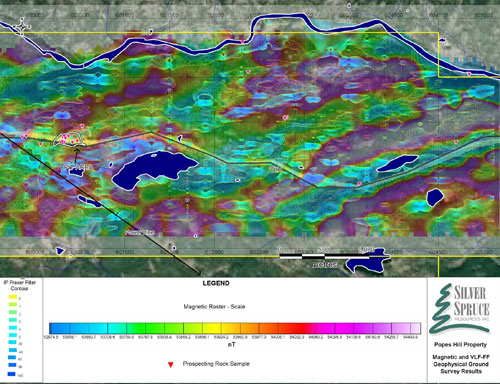
- Anomalous magnetic and VLF-EM trends identified across the surveyed area
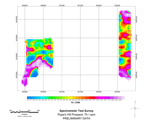
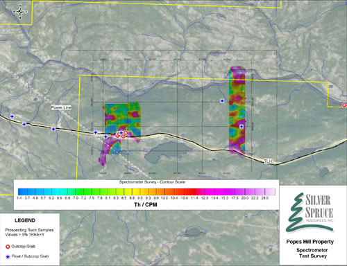
- Radiometric survey shows radioactivity associated with REE mineralization in the pit and elsewhere on the grid
January 6, 2011 - Bridgewater, NS - Silver Spruce Resources Inc. (TSXV: SSE) is pleased to announce further results from ground geophysical surveys carried out on the 100% owned Pope's Hill (PH) REE property located on the Trans Labrador Highway (TLH) in south central Labrador. The 73 line km geophysical survey of magnetics, VLF-EM and limited radiometrics was carried out in December under contract by Abitibi Geophysics of St Johns, Newfoundland. The surveys were focused on the original 62 claim block, which covers a 5 kilometer long trend of rare earth mineralization located in bedrock and angular boulders along and just to the north of the TLH. The surveys included GPS controlled magnetics, with readings taken every 2 seconds, VLF-EM with readings at 12.5 meter spacing and radiometrics, also at 12.5 meter spacing, over selected areas, covering some of the magnetic and electromagnetic anomalies located (see news release dated Dec. 30, 2010). The radiometric survey was limited in extent due to inclimate weather and was further hampered by snow cover which can affect the readings. The survey covered two small areas (4 lines) at 200 m intervals in the area of the bedrock pit and an area further to the east (2 lines) at 200 m intervals, which extended from the highway to the Pinus river to the north. The rare earth mineralization is variably non magnetic to magnetic and is associated with thorium/uranium making the samples radioactive and therefore responsive to radiometric surveys. The REE mineralization also appears to be shear hosted and the shear systems appear to respond to the VLF-EM survey.
The magnetics and VLF-EM show a number of linear magnetic anomalies, both positive and negative, crossing the property in an ENE direction. A number of the VLF-EM anomalies are coincident with, or marginal to, the magnetic highs with others in the magnetic low areas. A VLF-EM anomaly, between magnetic high zones, possibly indicating a shear system, occurs coincident with the anomalous REE samples in the bedrock aggregate pit on the side of the TLH and extends along strike to the east and west. The radiometric survey over this area shows a relatively strong, 1,000-1,500 total counts per minute (tcpm) and thorium anomaly coincident with the pit area and coincident VLF-EM anomaly which extends to the east and west along strike, over a 100 m plus strike length, and which is open to the west. Radiometric anomalies of 500 to > 1000 tcpm over background were also located in the central part of the grid, approximately 2 km to the east of the pit. No follow up has been carried out.
The geophysical and coincident prospecting targets will be tested by a diamond drill program planned for late January, 2011. The exploration application for the diamond drill program has been submitted to the Newfoundland government and a drill bid request has been sent to five Newfoundland based diamond drilling companies.
The original PH 62 claim property (1,550 ha) is located in the Pope's Hill area, approximately 100 km from Goose Bay along the paved portion of the TLH. The claims were acquired to cover thorium and REE mineralization located in 2006 during uranium exploration when values of up to 7.9% total rare earth elements plus yttrium (TREE+Y) were located (see news release dated May 6, 2010). Thirty-one samples were taken in follow up exploration in October (see news release dated Oct. 28, 2010). All samples gave anomalous TREE+Y values with 16 > 5%, and 5 > 10% with a high value of 24% TREE+Y. TREE+Y values varied from a low of 0.07% to a high of 24.07% averaging 5.73% for the 31 samples, which included 7 "host rock" samples, with values < 0.2%. The anomalous trend has been traced over a 7 km strike length extending to the east, approximately 4 km, and to the west, approximately 3 km, from a bedrock aggregate pit on the TLH. The highest REE values are in a dark grey to black sub-metallic mineral in veins which are variably non magnetic to moderately magnetic. All of the REE bearing samples are weakly to moderately radioactive with significant thorium content and minor uranium values generally < 100 ppm.
Rock units on the claims are mapped as granitic to mafic gneisses of late Paleoproterozoic age, with some pegmatites. Linear monzonite bodies, possibly related to a major structure, lie just to the north and south, along strike, of the mineralized area. Syenites and/or granitic units of peralkaline affinity have been noted.
Maps showing the property location, a compilation map for the property, the geophysical results and a picture of the bedrock pit can be viewed on the company website at www.silverspruceresources.com.
A total of 1,297 claims (324 km2), extending 40 km northeast and 40 km southwest of the original showings, were acquired by SSE in late October (news release Oct. 28, 2010) to protect the on-strike extensions of the mineralized zone and strongly anomalous lake sediment values in La and Ce with values up to 690 ppm against a background of 30 ppm. The 100% owned property, with the original 62 claim property included, now totals 1,359 claims (approx. 340 km2).
Analyses on the Pope's Hill rock samples in 2006 were carried out at the ACME Laboratories facility in Vancouver, BC after sample preparation at Eastern Analytical in Springdale, NL. They were analyzed by a REE package (Group 4B REE), which consists of a 0.2 g sample treated by a LiBO2 fusion followed by an ICPMS finish. All 2010 rock analyses are done at the Activation Laboratories (Actlabs) facility in Ancaster, Ontario after sample preparation at their facility in Goose Bay. The analysis is by their Code 8 REE package which uses a lithium borate fusion and then analysis by either ICP or ICP-MS. Values were checked by Actlabs using internal standards.
ABOUT SILVER SPRUCE
Silver Spruce is a junior exploration company originally focused on uranium in the Central Mineral Belt (CMB) and elsewhere in Labrador, Canada. With interests in more than 6000 claims totaling more than 1,500 square kilometers in Labrador, Silver Spruce is the second largest landholder in one of the world's premier emerging uranium districts. The company also has rare earth element (REE) properties in Labrador - Pope's Hill, RWM and the Straits and gold/silver projects in Mexico and the island of Newfoundland making Silver Spruce a leading explorer in Canada and Mexico.
This release has been approved by Peter Dimmell, P.Geo., Vice President of Exploration, Silver Spruce Resources Inc., who is a Qualified Person (QP) as defined in National Instrument 43-101.
For Further Information Contact:
SILVER SPRUCE RESOURCES
HEAD OFFICE
Gordon Barnhill, CFO & Director
Phone: 902.527.5700
Fax: 902.527.5711
E-mail: gbarnhill@silverspruceresources.com
Web: www.silverspruceresources.com
INVESTOR RELATIONS
Hugh Oswald, Ascenta Capital Partners Inc.
Phone: 604.684.4743 ext. 243
Toll Free: 1.866.684.4743 ext. 243
E-mail: hugh@ascentacapital.com
Web: www.ascentacapital.com
Neither TSX Venture Exchange nor its Regulation Services Provider (as that term is defined in the policies of the TSX Venture Exchange) accepts responsibility for the adequacy or accuracy of this release.
The Corporation seeks Safe Harbour.


