August 2, 2007
- Values from 0.06% to 3.37% U3O8 from float and outcrop samples
- Baseline environmental work completed
- Acquisition of new claims in the CMB east
August 2, 2007, Bridgewater, NS - Silver Spruce Resources Inc. (TSXV: SSE) announces further results of ground follow up in the T 649 showing area of the Mount Benedict (MB) Property, located in the eastern portion of the Central Mineral Belt, east central Labrador.
Two rock samples were taken from outcrop and ten from float downstream of the T-649 showing for a total of 12 samples. The samples gave values ranging from 0.06% to 3.37% U3O8 with three values greater than 1%. Uranophane was noted on both the outcrop and on the float boulders. The float boulders in the stream, which vary from fist size to a metre or so in diameter, appear to have been derived directly from the T-649 zone outcrop.
The company announced the discovery of the T-649 zone on July 26, 2007. It was located while following up on airborne Target 24, on the coast of Labrador and approximately 50 km to the south of the town of Makkovik. The zone consists of outcrop in a brook carrying intense radioactivity with total count values > 10,000 cps over a minimum width of 10 m. The zone strikes across the brook and disappears under the overburden, remaining open to the east and west along strike. As reported in the July 26 news release, five grab samples (AT-649-1 to AT-649-5) taken from bedrock in the zone, showed uranium mineralization averaging 0.497% U3O8 with values of 0.186%, 0.997%, 0.046%, 0.463%, and 0.796% U3O8 in samples one through five from the zone. New data includes two more samples taken from the outcrop (samples 65507 and 65508) which gave values of 0.21% and 0.06% U3O8. Sample 65507, which gave 0.21% U3O8, was taken at the same location as AT-649-3 which gave 0.046% U3O8, indicating some variability in the mineralization probably related to the density of fracturing / veining. Sample 65508 was taken near the margin of the zone to the south.
The host rock appears to be a fine grained, feldspar rich (plagioclase), felsic intrusive of the Benedict Mountains Intrusive Suite (BMIS) which has been fractured and veined with urananite/pitchblende and which shows extensive yellow uranophane staining. Minor sulphides (pyrite -- pyrrhotite) and extensive iron oxides are associated.
The company also reports that it has acquired more claims in the area to protect areas considered favourable for similar style uranium mineralization. Five hundred claims were staked on to the southern boundary of the group to bring the total for the MB property to 3,695 claims (92,375 ha, 923.75 km2) and 456 claims (11,400 ha, 114 km2) were staked in a separate group in the Tukialuk Bay area. All of the claims are owned 100% by Silver Spruce, subject to a 1% NSR payable to the optioner on production from 532 of the original 2006 claims.
The samples were analyzed at Actlabs in Ancaster ON, for uranium by delayed neutron counting (DNC), XRF for samples > 1% U3O8 and an ICP technique for other elements. Results for the ICP, including thorium, remain pending.
The company also reports that Minaskuat Limited Partnership, an environmental consulting firm based in Happy Valley -- Goose Bay, Labrador, has completed a baseline environmental survey in the area of the discovery.
Further results will be reported as they are received. Maps showing a schematic plan map of the sampling, a plan map for airborne targets and a table showing the new results are available on the company website at www.silverspruceresources.com.
This release has been approved by Peter Dimmell, P.Geo., Vice President of Exploration, who is a Qualified Person (QP) as defined in National Instrument 43-101.
ABOUT SILVER SPRUCE
Silver Spruce Resources Inc. (TSXV: SSE) is a junior exploration company primarily focused on uranium in the Central Mineral Belt (CMB) and other areas of potential in Labrador, Canada. With interests in over 12,500 claims totaling approximately 3,100 square kilometres, Silver Spruce is one of the largest landholder in one of the world's premier emerging uranium districts. The large ground position, experienced partners, and strong financial backing, make Silver Spruce a leading uranium explorer.
For Further Information Contact:
SILVER SPRUCE RESOURCES HEAD OFFICE
Gordon Barnhill, CFO & Director
Phone: 902.527.5700
Fax: 902.527.5711
E-mail: gbarnhill@silverspruceresources.com
Web: www.silverspruceresources.com
INVESTOR RELATIONS
Keir Reynolds, Ascenta Capital Partners Inc.
Phone: 604.684.4743 ext. 231
Toll Free: 1.866.684.4743 ext. 231
E-mail: keir@ascentacapital.com
Web: www.ascentacapital.com
The TSX Venture Exchange does not accept responsibility for the adequacy or accuracy of this release. The Company seeks Safe Harbour.
Rock Samples Location / Description - T 649 showing area - Lic. 12440M
cps - total counts per second; fg - fine grained; flt - float; gd - granodiorite; o/c - outcrop; py - pyrite
- Baseline environmental work completed
- Acquisition of new claims in the CMB east
August 2, 2007, Bridgewater, NS - Silver Spruce Resources Inc. (TSXV: SSE) announces further results of ground follow up in the T 649 showing area of the Mount Benedict (MB) Property, located in the eastern portion of the Central Mineral Belt, east central Labrador.
Two rock samples were taken from outcrop and ten from float downstream of the T-649 showing for a total of 12 samples. The samples gave values ranging from 0.06% to 3.37% U3O8 with three values greater than 1%. Uranophane was noted on both the outcrop and on the float boulders. The float boulders in the stream, which vary from fist size to a metre or so in diameter, appear to have been derived directly from the T-649 zone outcrop.
The company announced the discovery of the T-649 zone on July 26, 2007. It was located while following up on airborne Target 24, on the coast of Labrador and approximately 50 km to the south of the town of Makkovik. The zone consists of outcrop in a brook carrying intense radioactivity with total count values > 10,000 cps over a minimum width of 10 m. The zone strikes across the brook and disappears under the overburden, remaining open to the east and west along strike. As reported in the July 26 news release, five grab samples (AT-649-1 to AT-649-5) taken from bedrock in the zone, showed uranium mineralization averaging 0.497% U3O8 with values of 0.186%, 0.997%, 0.046%, 0.463%, and 0.796% U3O8 in samples one through five from the zone. New data includes two more samples taken from the outcrop (samples 65507 and 65508) which gave values of 0.21% and 0.06% U3O8. Sample 65507, which gave 0.21% U3O8, was taken at the same location as AT-649-3 which gave 0.046% U3O8, indicating some variability in the mineralization probably related to the density of fracturing / veining. Sample 65508 was taken near the margin of the zone to the south.
The host rock appears to be a fine grained, feldspar rich (plagioclase), felsic intrusive of the Benedict Mountains Intrusive Suite (BMIS) which has been fractured and veined with urananite/pitchblende and which shows extensive yellow uranophane staining. Minor sulphides (pyrite -- pyrrhotite) and extensive iron oxides are associated.
The company also reports that it has acquired more claims in the area to protect areas considered favourable for similar style uranium mineralization. Five hundred claims were staked on to the southern boundary of the group to bring the total for the MB property to 3,695 claims (92,375 ha, 923.75 km2) and 456 claims (11,400 ha, 114 km2) were staked in a separate group in the Tukialuk Bay area. All of the claims are owned 100% by Silver Spruce, subject to a 1% NSR payable to the optioner on production from 532 of the original 2006 claims.
The samples were analyzed at Actlabs in Ancaster ON, for uranium by delayed neutron counting (DNC), XRF for samples > 1% U3O8 and an ICP technique for other elements. Results for the ICP, including thorium, remain pending.
The company also reports that Minaskuat Limited Partnership, an environmental consulting firm based in Happy Valley -- Goose Bay, Labrador, has completed a baseline environmental survey in the area of the discovery.
Further results will be reported as they are received. Maps showing a schematic plan map of the sampling, a plan map for airborne targets and a table showing the new results are available on the company website at www.silverspruceresources.com.
This release has been approved by Peter Dimmell, P.Geo., Vice President of Exploration, who is a Qualified Person (QP) as defined in National Instrument 43-101.
ABOUT SILVER SPRUCE
Silver Spruce Resources Inc. (TSXV: SSE) is a junior exploration company primarily focused on uranium in the Central Mineral Belt (CMB) and other areas of potential in Labrador, Canada. With interests in over 12,500 claims totaling approximately 3,100 square kilometres, Silver Spruce is one of the largest landholder in one of the world's premier emerging uranium districts. The large ground position, experienced partners, and strong financial backing, make Silver Spruce a leading uranium explorer.
For Further Information Contact:
SILVER SPRUCE RESOURCES HEAD OFFICE
Gordon Barnhill, CFO & Director
Phone: 902.527.5700
Fax: 902.527.5711
E-mail: gbarnhill@silverspruceresources.com
Web: www.silverspruceresources.com
INVESTOR RELATIONS
Keir Reynolds, Ascenta Capital Partners Inc.
Phone: 604.684.4743 ext. 231
Toll Free: 1.866.684.4743 ext. 231
E-mail: keir@ascentacapital.com
Web: www.ascentacapital.com
The TSX Venture Exchange does not accept responsibility for the adequacy or accuracy of this release. The Company seeks Safe Harbour.
Rock Samples Location / Description - T 649 showing area - Lic. 12440M
| UTM | UTM | U | U3O8 | cps | cps | type | |||
| Sample # | East | North | ppm | % | on o/c | in bag | sample | flt / o/c | Description |
| A065502 | 382669 | 6072298 | 3830 | 0.45 | 7000 | 2600 | grab | flt | magnetite rich fg gd |
| A065503 | 382656 | 6072297 | 3080 | 0.36 | 7000 | 2400 | " | " | magnetite rich fg gd |
| A065504 | 382640 | 6072287 | 3530 | 0.42 | 8000 | 3579 | " | " | magnetite rich fg gd |
| A065505 | 382634 | 6072291 | > 10000 | 3.23 | 9000 | 6845 | " | " | magnetite rich fg gd |
| A065507 | 382490 | 6072108 | 1820 | 0.21 | 10000 | 2000 | " | o/c | magnetite rich fg gd |
| A065508 | 382490 | 6072099 | 546 | 0.06 | 10000 | 850 | " | " | magnetite rich fg gd |
| A065509 | 382609 | 6072270 | > 10000 | 1.92 | 10000 | 10000 | " | flt | uranophane; magnetite rich fg gd |
| A065510 | 382610 | 6072221 | 5910 | 0.70 | 10000 | 5129 | sel grab | " | minor py; magnetic; pink to dark gray gd |
| A065527 | 382685 | 6072290 | 5220 | 0.62 | 3100 | 2600 | grab | " | magnetite rich fg gd |
| A065528 | 382620 | 6072227 | 2000 | 0.24 | 3000 | 1987 | " | " | magnetite rich fg gd |
| A065529 | 382617 | 6072217 | 2780 | 0.33 | 7500 | 2650 | " | " | magnetite rich fg gd |
| A065530 | 382614 | 6072213 | > 10000 | 3.37 | 10000 | 10000 | " | " | magnetite rich fg gd |
cps - total counts per second; fg - fine grained; flt - float; gd - granodiorite; o/c - outcrop; py - pyrite
click to enlarge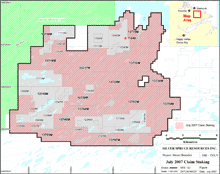 Mt. Benedict July 2007 Claim Staking |
click to enlarge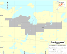 Tukialuk Bay Claim Location |
click to enlarge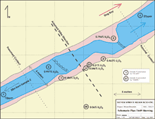 Mt. Benedict T649 Showing |
click to enlarge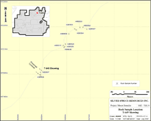 Mt. Benedict T649 Showing Rock Sample Location |