August 12, 2008
Highlights
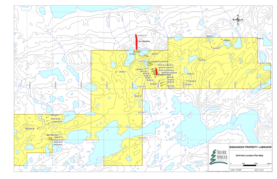
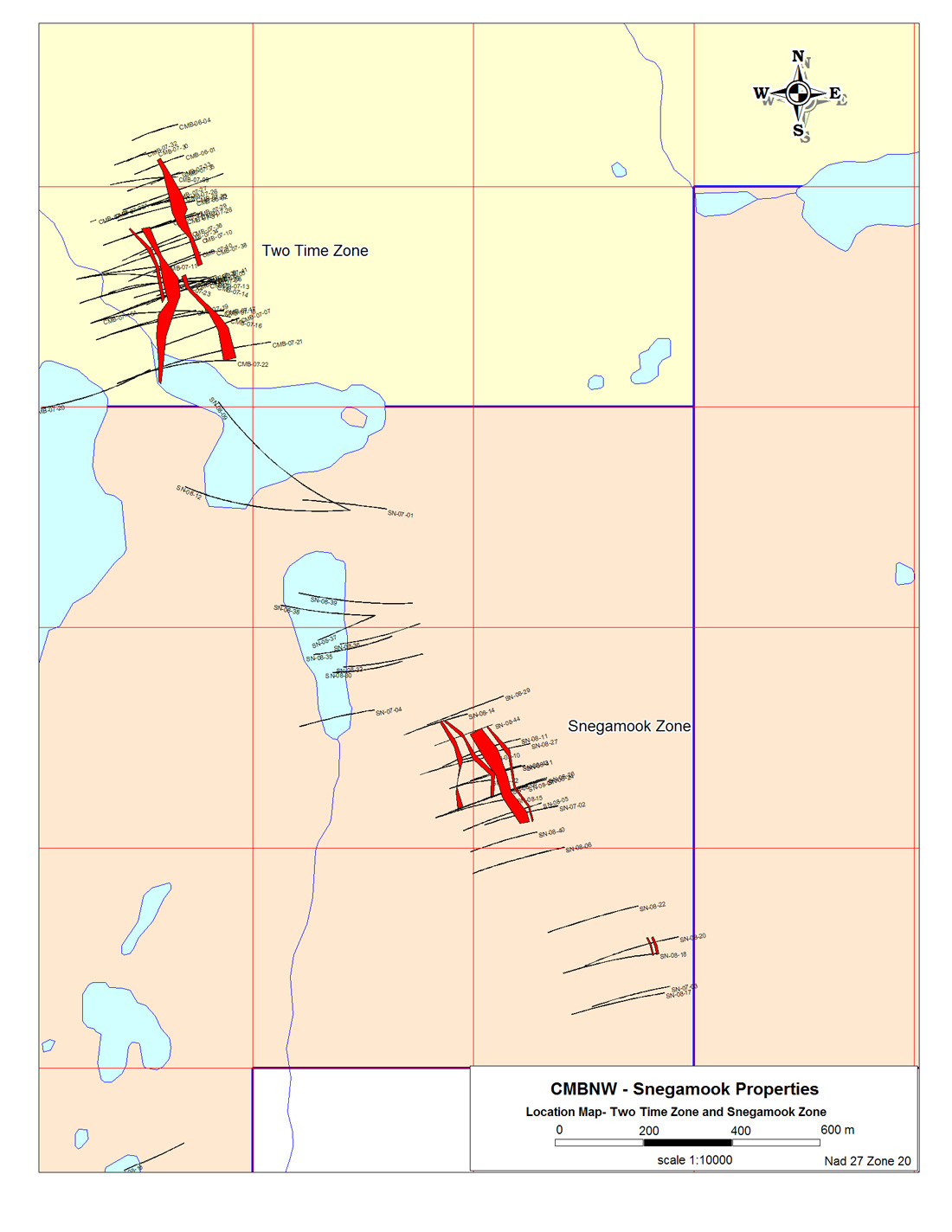
A new uranium bearing zone (the Snegamook Zone) has been located 1.3 km south-southeast, of the Two Time Zone, which lies on the CMB JV property jointly owned by Silver Spruce (40%) and Crosshair Exploration and Mining (60%). The Two Time Zone has 43-101 compliant resources of 2.3 M lbs of uranium indicated and 3.7 M lbs of uranium inferred. The Snegamook Zone, located by radon gas surveys, occurs along the same structural corridor that hosts the Two Time Zone. A total of 17 drill holes (SN-07-2,5,6,SN-08-8,10,11,12,14,15,24,26,27,29,40-44) have tested the new zone, all intersecting a 20 to 50 meter wide section of uranium bearing, brecciated and/or altered monzodiorite with moderate to strong chlorite, hematite and carbonate alteration, the same geological setting as the Two Time Zone. Four individual mineralized zones were identified and traced over a strike length of 300 meters and to a vertical depth of 200 meters. The zones are shallow dipping (15 to 20 degrees to the west) and vary in width from five to 53 meters with grades ranging from 225 to 771 ppm U3O8. Individual one meter values range from 50 to 1,110 ppm U308, with the widest section in SN-08-8 averaging 206 ppm U308 (0.41 lbs/ton) over 73 meters, similar to values located in the Phase 1 drill program on the Two Time Zone. Higher grade zones, 0.11% (2.13 lbs/ton) U308 over three meters and 0.11% (2.22 lbs/ton) U308 over two meters, were located in SN-08-18. The zones appear to be disrupted to the south and down dip by steeply dipping fault structures that displace the basement gneiss units. The zones remain open to the north. Additional drilling is required to delineate the size of the deposit.
Two drill holes (SN-08-18 and SN-08-20) tested another radon anomaly 500 meters to the south of the Snegamook Zone. They intersected nine meters (210 to 219 meters) of 552 ppm U3O8 and five meters (191 to 196 meters) of 224 ppm U3O8. Additional drilling is required to determine the significance of these intersections.
Holes SN-08-09 and SN-08-12, designed to target the projected down dip extension of the Two Time Zone on the Snegamook property, failed to reach planned targets due to unexpected hole deviations.
Four drill holes targeted the Near Miss Showing and all intersected erratic uranium mineralization over narrow widths hosted in hematized, brecciated, granitic to monzodioritic units. Drill holes SNNM-08-03 and 04 were targeted 50 meters to the west of 2007 holes SNNM-07-01 and 02, which tested the Near Miss showing. Both holes intersected hematite microbreccias, with individual one meter intervals grading from 113 to 2,117 ppm U308 and the widest intersection averaging 213 ppm U308 (0.43 lbs/ton) over 16 meters including one meter of 0.21% (4.23 lbs/ton) U308. The mineralization is developed proximal to and along the contact with the older Archean Gneiss, which is dipping shallowly to the east. Additional drilling will be required to determine the significance of the zone.
Drill holes SNNM-08-05 to SNNM-08-09 targeted coincident airborne radiometric and radon gas anomalies 500 meters to one kilometer to the north of the Near Miss Showing. No significant mineralization was intersected and to date the anomalies remain unexplained.
Four holes (SN-08-13, 16, 19 and 21), tested areas away from known mineralized trends. Two holes, SN-08-13 and 16 targeted strong radon gas anomalies approximately one kilometer to the west of the Two Time Zone extension area. No significant mineralization was intersected and the anomalies remain unexplained. Two holes, SN-08-19 and 21, targeted strong radon gas anomalies coinciding with anomalous grab samples from outcrop, approximately two kilometers to the east of the Two Time Zone extension, on Licence 11472M. Both holes located weak radioactivity, as defined by total count scintillometer, in brecciated pegmatite with moderate to strong hematite alteration. Sample values were insignificant, however more work is required in this area as the radon gas anomalies are some of the strongest located in the surveys of the area.
A total of 13,765.3 meters have been drilled in 53 holes on the Snegamook property, with 44 holes totalling 12,385.3 meters drilled in 2008. Forty-four drill holes (SN-07-1 to 7, SN-08-8 to 44)) tested targets on the main Snegamook property, while nine holes (SNNM-07-1, 2 and SNNM-08-3 to 9) tested the Near Miss Showing area, in the western portion of the property.
"New discoveries such as the Two Time Zone, the Snegamook Zone and the uranium mineralized drill intersections recently found on the Mount Benedict property are testament to the excellent uranium potential that exists in the Central Mineral Belt of Labrador and to skill with which the Silver Spruce exploration team carries out business," states Lloyd Hillier, president of Silver Spruce. "We have a 40-person exploration crew working out of two base camps completing large scale reconnaissance programs and detailed follow-up work on all our Labrador properties. We are confident that with continued hard work and perseverance, we will be successful in making even more discoveries."
ANALYSIS
All analyses are being done at the Activation Laboratories (Actlabs) facility in Ancaster, Ontario, after sample preparation at the Actlabs prep facility in Goose Bay. Uranium and other elements are analyzed by an ICP technique. If this yields results in excess of 250 ppm uranium, follow-up by delayed neutron counting (DNC) is performed. A quality assurance/quality control (QA/QC) program, described on the Silver Spruce website, is in place to increase confidence in the results generated.
Plan maps showing the drilling on the Snegamook Property, including the Snegamook Zone, can be viewed on the company website www.silverspruceresources.com.
ABOUT THE SNEGAMOOK PROPERTY
The Snegamook claim block is an 86-claim (21.5 km2) property located just to the southeast of Snegamook Lake. It is surrounded by the CMBNW JV property to the north, west and east and the Santoy "Fishhawk Lake" property to the south. Silver Spruce has earned a 100% interest in the property, subject to a 2% NSR. It is located outside of lands owned by the Nunatsiavut government, on lands subject to the Innu Land Claim, and is not subject to the recently announced moratorium on development which applies to the Labrador Inuit Lands (LIL) only.
ABOUT SILVER SPRUCE
Silver Spruce is a junior exploration company focused on uranium in the Central Mineral Belt (CMB) of Labrador, Canada and gold/silver in Mexico. With interests in more than 10,000 claims totaling more than 2,500 km2 in Labrador, Silver Spruce is the second largest landholder in one of the world's premier emerging uranium districts. The exposure to gold/silver opportunities in Mexico, and base metals in central Newfoundland and Labrador, gives the corporation diversification without losing its uranium focus. Strong financial backing makes Silver Spruce a leading explorer in Canada and Mexico.
This release has been approved by Peter Dimmell, P.Geo., Vice President of Exploration, Silver Spruce Resources Inc., who is a Qualified Person (QP) as defined in National Instrument 43-101.
For Further Information Contact:
SILVER SPRUCE RESOURCES
HEAD OFFICE
Gordon Barnhill, CFO & Director
Phone: 902.527.5700
Fax: 902.527.5711
E-mail: gbarnhill@silverspruceresources.com
Web: www.silverspruceresources.com
INVESTOR RELATIONS
Hugh Oswald, Ascenta Capital Partners Inc.
Phone: 604.684.4743 ext. 243
Toll Free: 1.866.684.4743 ext. 243
E-mail: hugh@ascentacapital.com
Web: www.ascentacapital.com
The TSX Venture Exchange does not accept responsibility for the adequacy or accuracy of this release. The company seeks Safe Harbour.
Click to enlarge maps
- New uranium zone discovered (the Snegamook Zone)
- New Zone remains open to the north and to depth
- Additional new mineralized zones found on strike to the south
A new uranium bearing zone (the Snegamook Zone) has been located 1.3 km south-southeast, of the Two Time Zone, which lies on the CMB JV property jointly owned by Silver Spruce (40%) and Crosshair Exploration and Mining (60%). The Two Time Zone has 43-101 compliant resources of 2.3 M lbs of uranium indicated and 3.7 M lbs of uranium inferred. The Snegamook Zone, located by radon gas surveys, occurs along the same structural corridor that hosts the Two Time Zone. A total of 17 drill holes (SN-07-2,5,6,SN-08-8,10,11,12,14,15,24,26,27,29,40-44) have tested the new zone, all intersecting a 20 to 50 meter wide section of uranium bearing, brecciated and/or altered monzodiorite with moderate to strong chlorite, hematite and carbonate alteration, the same geological setting as the Two Time Zone. Four individual mineralized zones were identified and traced over a strike length of 300 meters and to a vertical depth of 200 meters. The zones are shallow dipping (15 to 20 degrees to the west) and vary in width from five to 53 meters with grades ranging from 225 to 771 ppm U3O8. Individual one meter values range from 50 to 1,110 ppm U308, with the widest section in SN-08-8 averaging 206 ppm U308 (0.41 lbs/ton) over 73 meters, similar to values located in the Phase 1 drill program on the Two Time Zone. Higher grade zones, 0.11% (2.13 lbs/ton) U308 over three meters and 0.11% (2.22 lbs/ton) U308 over two meters, were located in SN-08-18. The zones appear to be disrupted to the south and down dip by steeply dipping fault structures that displace the basement gneiss units. The zones remain open to the north. Additional drilling is required to delineate the size of the deposit.
Two drill holes (SN-08-18 and SN-08-20) tested another radon anomaly 500 meters to the south of the Snegamook Zone. They intersected nine meters (210 to 219 meters) of 552 ppm U3O8 and five meters (191 to 196 meters) of 224 ppm U3O8. Additional drilling is required to determine the significance of these intersections.
Holes SN-08-09 and SN-08-12, designed to target the projected down dip extension of the Two Time Zone on the Snegamook property, failed to reach planned targets due to unexpected hole deviations.
Four drill holes targeted the Near Miss Showing and all intersected erratic uranium mineralization over narrow widths hosted in hematized, brecciated, granitic to monzodioritic units. Drill holes SNNM-08-03 and 04 were targeted 50 meters to the west of 2007 holes SNNM-07-01 and 02, which tested the Near Miss showing. Both holes intersected hematite microbreccias, with individual one meter intervals grading from 113 to 2,117 ppm U308 and the widest intersection averaging 213 ppm U308 (0.43 lbs/ton) over 16 meters including one meter of 0.21% (4.23 lbs/ton) U308. The mineralization is developed proximal to and along the contact with the older Archean Gneiss, which is dipping shallowly to the east. Additional drilling will be required to determine the significance of the zone.
Drill holes SNNM-08-05 to SNNM-08-09 targeted coincident airborne radiometric and radon gas anomalies 500 meters to one kilometer to the north of the Near Miss Showing. No significant mineralization was intersected and to date the anomalies remain unexplained.
Four holes (SN-08-13, 16, 19 and 21), tested areas away from known mineralized trends. Two holes, SN-08-13 and 16 targeted strong radon gas anomalies approximately one kilometer to the west of the Two Time Zone extension area. No significant mineralization was intersected and the anomalies remain unexplained. Two holes, SN-08-19 and 21, targeted strong radon gas anomalies coinciding with anomalous grab samples from outcrop, approximately two kilometers to the east of the Two Time Zone extension, on Licence 11472M. Both holes located weak radioactivity, as defined by total count scintillometer, in brecciated pegmatite with moderate to strong hematite alteration. Sample values were insignificant, however more work is required in this area as the radon gas anomalies are some of the strongest located in the surveys of the area.
A total of 13,765.3 meters have been drilled in 53 holes on the Snegamook property, with 44 holes totalling 12,385.3 meters drilled in 2008. Forty-four drill holes (SN-07-1 to 7, SN-08-8 to 44)) tested targets on the main Snegamook property, while nine holes (SNNM-07-1, 2 and SNNM-08-3 to 9) tested the Near Miss Showing area, in the western portion of the property.
"New discoveries such as the Two Time Zone, the Snegamook Zone and the uranium mineralized drill intersections recently found on the Mount Benedict property are testament to the excellent uranium potential that exists in the Central Mineral Belt of Labrador and to skill with which the Silver Spruce exploration team carries out business," states Lloyd Hillier, president of Silver Spruce. "We have a 40-person exploration crew working out of two base camps completing large scale reconnaissance programs and detailed follow-up work on all our Labrador properties. We are confident that with continued hard work and perseverance, we will be successful in making even more discoveries."
ANALYSIS
All analyses are being done at the Activation Laboratories (Actlabs) facility in Ancaster, Ontario, after sample preparation at the Actlabs prep facility in Goose Bay. Uranium and other elements are analyzed by an ICP technique. If this yields results in excess of 250 ppm uranium, follow-up by delayed neutron counting (DNC) is performed. A quality assurance/quality control (QA/QC) program, described on the Silver Spruce website, is in place to increase confidence in the results generated.
Plan maps showing the drilling on the Snegamook Property, including the Snegamook Zone, can be viewed on the company website www.silverspruceresources.com.
ABOUT THE SNEGAMOOK PROPERTY
The Snegamook claim block is an 86-claim (21.5 km2) property located just to the southeast of Snegamook Lake. It is surrounded by the CMBNW JV property to the north, west and east and the Santoy "Fishhawk Lake" property to the south. Silver Spruce has earned a 100% interest in the property, subject to a 2% NSR. It is located outside of lands owned by the Nunatsiavut government, on lands subject to the Innu Land Claim, and is not subject to the recently announced moratorium on development which applies to the Labrador Inuit Lands (LIL) only.
ABOUT SILVER SPRUCE
Silver Spruce is a junior exploration company focused on uranium in the Central Mineral Belt (CMB) of Labrador, Canada and gold/silver in Mexico. With interests in more than 10,000 claims totaling more than 2,500 km2 in Labrador, Silver Spruce is the second largest landholder in one of the world's premier emerging uranium districts. The exposure to gold/silver opportunities in Mexico, and base metals in central Newfoundland and Labrador, gives the corporation diversification without losing its uranium focus. Strong financial backing makes Silver Spruce a leading explorer in Canada and Mexico.
This release has been approved by Peter Dimmell, P.Geo., Vice President of Exploration, Silver Spruce Resources Inc., who is a Qualified Person (QP) as defined in National Instrument 43-101.
For Further Information Contact:
SILVER SPRUCE RESOURCES
HEAD OFFICE
Gordon Barnhill, CFO & Director
Phone: 902.527.5700
Fax: 902.527.5711
E-mail: gbarnhill@silverspruceresources.com
Web: www.silverspruceresources.com
INVESTOR RELATIONS
Hugh Oswald, Ascenta Capital Partners Inc.
Phone: 604.684.4743 ext. 243
Toll Free: 1.866.684.4743 ext. 243
E-mail: hugh@ascentacapital.com
Web: www.ascentacapital.com
The TSX Venture Exchange does not accept responsibility for the adequacy or accuracy of this release. The company seeks Safe Harbour.
Click to enlarge maps
 Snegamook Drill Hole Location Map for Aug 12 08 |
 Snegamook Property Location Map for Aug 12 08 |
| TABLE 2 - ANALYTICAL RESULTS | ||||||
| Silver Spruce Resources Inc. | ||||||
| 2008 Diamond Drilling, Snegamook Property, SNNM-08-03 to 09, SN-08-05 to 44 | ||||||
| NEAR MISS DRILLING | ||||||
| DDH | From (m) | To (m) | Length (m) | U3O8 (ppm) | U3O8 (%) | U3O8 (lbs/ton) |
| SNNM-08-03 | 24.5 | 25.5 | 1.0 | 113.2 | 0.01 | 0.23 |
| SNNM-08-03 | 53.0 | 65.0 | 12.0 | 132.5 | 0.01 | 0.27 |
| " incl. | 53.0 | 54.0 | 1.0 | 331.4 | 0.03 | 0.66 |
| " incl. | 64.0 | 65.0 | 1.0 | 391.6 | 0.04 | 0.78 |
| " and | 73.0 | 74.0 | 1.0 | 436.4 | 0.04 | 0.87 |
| SNNM-08-04 | 49.0 | 65.0 | 16.0 | 213 | 0.02 | 0.43 |
| " incl. | 53.0 | 54.0 | 1.0 | 836.2 | 0.08 | 1.67 |
| " incl. | 57.0 | 58.0 | 1.0 | 455.2 | 0.05 | 0.91 |
| " and | 105.0 | 106.0 | 1.0 | 2116.8 | 0.21 | 4.23 |
| SNNM-08-05 | No Significant Intersections | |||||
| SNNM-08-06 | No Significant Intersections | |||||
| SNNM-08-07 | No Significant Intersections | |||||
| SNNM-08-08 | No Significant Intersections | |||||
| SNNM-08-09 | No Significant Intersections | |||||
| SNEGAMOOK DRILLING | ||||||
| DDH | From (m) | To (m) | Length (m) | U3O8 (ppm) | U3O8 (%) | U3O8 (lbs/ton) |
| SN-08-05 | 142.0 | 162.0 | 20.0 | 236.5 | 0.02 | 0.47 |
| " incl. | 151.0 | 161.0 | 10.0 | 416.6 | 0.04 | 0.83 |
| " incl. | 160.0 | 161.0 | 1.0 | 1154.6 | 0.12 | 2.31 |
| SN-08-06 | 97.9 | 102.4 | 4.5 | 1104.7 | 0.11 | 2.21 |
| " incl. | 100.9 | 101.4 | 0.5 | 9743 | 0.97 | 19.49 |
| SN-08-07 | 5.0 | 6.0 | 1.0 | 583.8 | 0.06 | 1.17 |
| " and | 96.0 | 163.0 | 67.0 | 187.5 | 0.02 | 0.38 |
| " incl. | 100.0 | 102.0 | 2.0 | 324.9 | 0.03 | 0.65 |
| " incl. | 113.0 | 116.0 | 3.0 | 489.5 | 0.05 | 0.98 |
| " incl. | 121.0 | 129.0 | 8.0 | 263.4 | 0.03 | 0.53 |
| " incl. | 150.0 | 155.0 | 5.0 | 552.2 | 0.06 | 1.10 |
| " incl. | 154.0 | 155.0 | 1.0 | 1090.9 | 0.11 | 2.18 |
| " incl. | 159.0 | 161.0 | 2.0 | 476.5 | 0.05 | 0.95 |
| SN-08-08 | 43.5 | 44.5 | 1.0 | 569.7 | 0.06 | 1.13 |
| " and | 68.0 | 84.0 | 16.0 | 168.9 | 0.02 | 0.34 |
| "incl. | 81.0 | 84.0 | 3.0 | 421.1 | 0.04 | 0.84 |
| " and | 130.0 | 203.0 | 73.0 | 205.8 | 0.02 | 0.41 |
| "incl. | 131.0 | 135.0 | 4.0 | 447.9 | 0.05 | 0.90 |
| "incl. | 142.0 | 145.0 | 3.0 | 315.3 | 0.03 | 0.63 |
| "incl. | 150.0 | 164.0 | 14.0 | 421.0 | 0.04 | 0.84 |
| "incl. | 151.0 | 153.0 | 2.0 | 914.0 | 0.09 | 1.80 |
| "incl. | 159.0 | 164.0 | 5.0 | 426.9 | 0.04 | 0.80 |
| "incl. | 169.0 | 173.0 | 4.0 | 276.3 | 0.03 | 0.54 |
| "incl. | 177.0 | 183.0 | 6.0 | 318.8 | 0.03 | 0.64 |
| SN-08-09 | No Significant Intersections | |||||
| SN-08-10 | 73.0 | 178.0 | 105.0 | 99.5 | 0.01 | 0.20 |
| " incl. | 99.0 | 106.0 | 7.0 | 314.4 | 0.03 | 0.63 |
| " incl. | 104.0 | 105.0 | 1.0 | 787.8 | 0.08 | 1.58 |
| " incl. | 149.0 | 155.0 | 6.0 | 220.2 | 0.02 | 0.44 |
| SN-08-11 | 42.0 | 206.0 | 164.0 | 131.4 | 0.01 | 0.26 |
| "incl. | 45.0 | 53.0 | 8.0 | 288.5 | 0.03 | 0.58 |
| "incl. | 71.0 | 81.0 | 10.0 | 272.2 | 0.03 | 0.54 |
| "incl. | 83.0 | 91.0 | 8.0 | 376.7 | 0.04 | 0.76 |
| "incl. | 145.0 | 150.0 | 5.0 | 302.4 | 0.03 | 0.60 |
| "incl. | 163.0 | 164.0 | 1.0 | 507.1 | 0.05 | 1.01 |
| SN-08-12 | 312.0 | 314.0 | 2.0 | 111.9 | 0.01 | 0.22 |
| " and | 735.0 | 735.5 | 0.5 | 277.2 | 0.03 | 0.55 |
| SN-08-13 | No Significant Intersections | |||||
| SN-08-14 | 71.0 | 90.0 | 19.0 | 109.5 | 0.01 | 0.22 |
| "incl. | 80.0 | 85.0 | 5.0 | 190.4 | 0.02 | 0.38 |
| SN-08-15 | 161.0 | 162.0 | 1.0 | 436.4 | 0.04 | 0.87 |
| " and | 282.0 | 307.0 | 25.0 | 159.0 | 0.02 | 0.32 |
| "incl. | 282.0 | 293.0 | 11.0 | 204.5 | 0.02 | 0.41 |
| "incl. | 305.0 | 307.0 | 2.0 | 604.4 | 0.06 | 1.21 |
| SN-08-16 | No Significant Intersections | |||||
| SN-08-17 | 208.0 | 210.0 | 2.0 | 165.4 | 0.02 | 0.33 |
| " and | 233.0 | 234.0 | 1.0 | 296.0 | 0.03 | 0.59 |
| SN-08-18 | 199.0 | 204.0 | 5.0 | 174.9 | 0.02 | 0.35 |
| " and | 210.0 | 219.0 | 9.0 | 552 | 0.06 | 1.10 |
| "incl. | 216.0 | 219.0 | 3.0 | 1065 | 0.11 | 2.13 |
| " and | 273.0 | 275.0 | 2.0 | 1110.4 | 0.11 | 2.22 |
| "incl. | 273.0 | 274.0 | 1.0 | 1745.5 | 0.17 | 3.49 |
| SN-08-19 | 56.0 | 56.5 | 0.5 | 179.3 | 0.02 | 0.36 |
| SN-08-20 | 191.0 | 196.0 | 5.0 | 223.6 | 0.02 | 0.45 |
| " and | 269.0 | 270.0 | 1.0 | 331.4 | 0.03 | 0.66 |
| SN-08-21 | No Significant Intersections | |||||
| SN-08-22 | No Significant Intersections | |||||
| SN-08-23 | No Significant Intersections | |||||
| SN-08-24 | 73 | 93 | 20 | 504.06 | 0.05 | 1.01 |
| "incl. | 82 | 93 | 11 | 674.81 | 0.07 | 1.35 |
| "incl. | 83 | 85 | 2 | 1180.55 | 0.12 | 2.36 |
| "incl. | 91 | 92 | 1 | 1297.3 | 0.13 | 2.59 |
| "and | 103 | 107 | 4 | 188.93 | 0.019 | 0.38 |
| SN-08-25 | No Significant Intersections | |||||
| SN-08-26 | No Significant Intersections | |||||
| SN-08-27 | 99 | 100 | 1 | 310.2 | 0.03 | 0.62 |
| "and | 108 | 121 | 13 | 394.64 | 0.04 | 0.79 |
| "incl. | 110 | 119 | 9 | 458.91 | 0.05 | 0.92 |
| "incl. | 112 | 114 | 2 | 762.45 | 0.08 | 1.52 |
| "and | 135 | 136 | 1 | 219.40 | 0.02 | 0.44 |
| SN-08-28 | No Significant Intersections | |||||
| SN-08-29 | 34 | 35 | 1 | 227.6 | 0.02 | 0.46 |
| SN-08-30 | No Significant Intersections | |||||
| SN-08-31 | No Significant Intersections | |||||
| SN-08-32 | 10 | 11 | 1 | 258.3 | 0.03 | 0.52 |
| "and | 139 | 140 | 1 | 201.7 | 0.02 | 0.40 |
| "and | 162 | 164 | 2 | 330.25 | 0.03 | 0.66 |
| SN-08-33 | No Significant Intersections | |||||
| SN-08-34 | No Significant Intersections | |||||
| SN-08-35 | 52 | 60 | 8 | 445.21 | 0.04 | 0.89 |
| "incl. | 54 | 59 | 5 | 580.50 | 0.06 | 1.16 |
| "incl. | 56 | 57 | 1 | 1497.80 | 0.15 | 3.00 |
| "and | 82 | 84 | 2 | 204.05 | 0.02 | 0.41 |
| SN-08-36 | No Significant Intersections | |||||
| SN-08-37 | 94 | 98 | 4 | 267.15 | 0.03 | 0.53 |
| "incl. | 97 | 98 | 1 | 493 | 0.05 | 0.99 |
| SN-08-38 | No Significant Intersections | |||||
| SN-08-39 | 136 | 138 | 2 | 413.4 | 0.04 | 0.83 |
| "and | 253 | 254 | 1 | 255.9 | 0.03 | 0.51 |
| SN-08-40 | 145 | 146 | 1 | 188.7 | 0.02 | 0.38 |
| SN-08-41 | 78 | 79 | 1 | 281.9 | 0.03 | 0.56 |
| "and | 84 | 131 | 47 | 221.07 | 0.02 | 0.44 |
| "incl. | 86 | 87 | 1 | 559.00 | 0.06 | 1.12 |
| "incl. | 105 | 112 | 7 | 402.00 | 0.04 | 0.80 |
| "and | 147 | 151 | 4 | 195.18 | 0.02 | 0.39 |
| SN-08-42 | 29 | 30 | 1 | 300.70 | 0.03 | 0.60 |
| "and | 58 | 59 | 1 | 390.40 | 0.04 | 0.78 |
| "and | 66.5 | 67.5 | 1 | 211.1 | 0.02 | 0.42 |
| "and | 102 | 103 | 1 | 329.1 | 0.03 | 0.66 |
| "and | 118 | 143 | 25 | 265.22 | 0.03 | 0.53 |
| SN-08-43 | 40 | 55 | 15 | 234.23 | 0.02 | 0.47 |
| "incl. | 50 | 51 | 1 | 569.70 | 0.06 | 1.14 |
| "and | 68 | 69 | 1 | 163.90 | 0.02 | 0.33 |
| "and | 70 | 71 | 1 | 193.40 | 0.02 | 0.39 |
| "and | 80 | 109 | 29 | 200.78 | 0.02 | 0.40 |
| "incl. | 88 | 89 | 1 | 405.70 | 0.04 | 0.81 |
| SN-08-44 | 66 | 72 | 6 | 291.32 | 0.03 | 0.58 |
| "incl. | 66 | 69 | 3 | 407.67 | 0.04 | 0.82 |
| "and | 80 | 84 | 4 | 184.60 | 0.02 | 0.37 |
| "and | 92 | 95 | 3 | 233.90 | 0.02 | 0.47 |
| "and | 110 | 119 | 9 | 186.21 | 0.02 | 0.37 |
| "and | 121 | 125 | 4 | 174.55 | 0.02 | 0.35 |
| "and | 135 | 139 | 4 | 219.68 | 0.02 | 0.44 |