- Wide zones of uranium mineralized hematite breccias, similar to Two Time Zone, with values to 206 ppm (0.41 lbs/ ton) U3O8 over 73 meters, including 2 meters of 0.09% (1.8 lbs/ton)
- Narrow high-grade zones on Near Miss - values to 0.21% (4.23 lbs/ton) U3O8 over 1 meter
April 24 , 2008 - Bridgewater, NS - Silver Spruce Resources Inc. (TSXV: SSE) is pleased to provide an update on the ongoing diamond drilling program on the Snegamook Property in the western portion of the Central Mineral Belt of Labrador. Silver Spruce has an option to earn a 100% interest in the Property, subject to a 2% Net Smelter Return (NSR).
The 2008 program is a follow up to the 2007 drill program (see news release dated November 27, 2007) targeting coincident airborne radiometric and strong untested radon gas anomalies, including areas south and east of the Two Time Zone and to the north of the Near Miss Showing, and mineralization located by prospecting and geological mapping. A total of 30 drill holes, including 24 (6,913 meters) in 2008, have been drilled to date.
Eleven holes (SN-08-5 to 8, 10, 11, 14, 15, 17, 18 and 20), totaling 4,735 meters, tested the Two Time trend over a two kilometer strike length, approximately 1.5 kilometers to the south of the Two Time Zone, on the CMBNW JV property. This trend was previously identified in 2007, by drill holes SN-07-02 and 03. The recent drilling has traced the uranium mineralization 800 meters to the north of SN-07-03. Twelve of 13 drill holes have intersected structurally controlled, brecciated monzodiorite, similar to the Two Time Zone mineralization, with moderate to strong chlorite, hematite and carbonate alteration in older intrusive and gneissic units. Individual one meter values range from 50 to 1,110 ppm U308, with the highest grade section in SN-08-8 averaging 206 ppm U308 (0.41 lbs/ton) over 73 meters, similar to values located in the Phase 1 drill program on the Two Time Zone. Higher grade zones, 0.11% (2.13 lbs/ton) U308 over three meters and 0.11% (2.22 lbs/ton) U308 over two meters were located in SN-08-18.
Two holes, SN-08-09 and SN-08-12, totaling 1,726 meters, tested the possible extension of the Two Time Zone at depth, approximately 600 meters to the south of the known zone on the CMBNW JV property to the north. Both holes failed to intersect mineralization. They deviated to the north, away from the proposed target, and failed to test the projected extension.
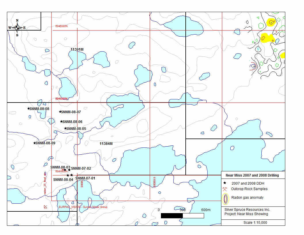
Two holes, SNNM-08-03 and 04, totaling 422 meters, were targeted 50 meters to the west of 2007 holes SNNM-07-01 and 02, which tested the Near Miss showing. Both holes intersected hematite microbreccias with individual one meter intervals grading from 113 to 2,117 ppm U308, with the widest intersection averaging 213 ppm U308 (0.43 lbs/ton) over 16 meters including one meter of 0.21% (4.23 lbs/ton) U308. The mineralization is developed proximal to and along the contact with the older Archean Gneiss.
Drill holes SNNM-08-05 to SNNM-08-09 (800 meters), targeted coincident airborne radiometric and radon gas anomalies, 500 meters to one-kilometer to the north of the Near Miss Showing. No significant mineralization was intersected and to date the anomalies remain unexplained.
Four holes (SN-08-13, 16, 19 and 21), totaling 1,224 meters, tested areas away from known mineralized trends. Two holes, SN-08-13 and 16 (432 meters), targeted strong radon gas anomalies approximately one kilometer to the west of the Two Time extension area. No significant mineralization was intersected and the anomalies remain unexplained. Two holes, SN-08-19 and 21 (474 meters), targeted strong radon gas anomalies coinciding with anomalous grab samples from outcrop, approximately two kilometers to the east of the Two Time Zone extension, on Licence 11472M. Both holes located weak radioactivity, as defined by total count scintillometer, in brecciated pegmatite with moderate to strong hematite alteration. Sample values were insignificant, however more work is required in this area as the radon gas anomalies are some of the strongest located in the surveys of the area.
TABLE 1 - ANALYTICAL RESULTS |
||||||
Silver Spruce Resources Inc. |
||||||
2008 Diamond Drilling, Snegamook Property, Central Mineral Belt, Labrador |
||||||
SNEGAMOOK - NEAR MISS DRILLING - SNNM-08-03 to 09 |
||||||
DDH |
From (m) |
To (m) |
Length (m) |
U3O8 (ppm) |
U3O8 (%) |
U3O8 (lbs/ton) |
SNNM-08-03 |
53.0 |
65.0 |
12.0 |
133 |
0.013 |
0.27 |
" |
73.0 |
74.0 |
1.0 |
436 |
0.044 |
0.87 |
SNNM-08-04 |
49.0 |
65.0 |
16.0 |
213 |
0.021 |
0.43 |
" incl. |
53.0 |
54.0 |
1.0 |
836 |
0.084 |
1.67 |
" and |
105.0 |
106.0 |
1.0 |
2117 |
0.212 |
4.23 |
SNNM-08-05 |
No Significant values |
|||||
SNNM-08-06 |
No Significant values |
|||||
SNNM-08-07 |
No Significant values |
|||||
SNNM-08-08 |
No Significant values |
|||||
SNNM-08-09 |
No Significant values |
|||||
SNEGAMOOK REGIONAL DRILLING - SN-08-05 to 21 |
||||||
DDH |
From (m) |
To (m) |
Length (m) |
U3O8 (ppm) |
U3O8 (%) |
U3O8 (lbs/ton) |
SN-08-05 |
142.0 |
162.0 |
20.0 |
237 |
0.024 |
0.47 |
" incl. |
151.0 |
161.0 |
10.0 |
417 |
0.042 |
0.83 |
" incl. |
160.0 |
161.0 |
1.0 |
1155 |
0.115 |
2.31 |
SN-08-06 |
97.9 |
102.4 |
4.5 |
1105 |
0.110 |
2.21 |
" incl. |
100.9 |
101.4 |
0.5 |
9743 |
0.974 |
19.49 |
SN-08-07 |
5.0 |
6.0 |
1.0 |
584 |
0.058 |
1.17 |
" and |
96.0 |
163.0 |
67.0 |
188 |
0.019 |
0.38 |
" incl. |
113.0 |
116.0 |
3.0 |
490 |
0.049 |
0.98 |
" incl. |
150.0 |
155.0 |
5.0 |
552 |
0.055 |
1.10 |
" incl. |
154.0 |
155.0 |
1.0 |
1091 |
0.109 |
2.18 |
" incl. |
159.0 |
161.0 |
2.0 |
477 |
0.048 |
0.95 |
SN-08-08 |
43.5 |
44.5 |
1.0 |
570 |
0.057 |
1.13 |
" and |
68.0 |
84.0 |
16.0 |
169 |
0.017 |
0.34 |
" incl. |
81.0 |
84.0 |
3.0 |
421 |
0.042 |
0.84 |
" and |
130.0 |
203.0 |
73.0 |
206 |
0.021 |
0.41 |
" incl. |
150.0 |
164.0 |
14.0 |
421 |
0.040 |
0.84 |
" incl. |
151.0 |
153.0 |
2.0 |
914 |
0.090 |
1.80 |
" incl. |
159.0 |
164.0 |
5.0 |
427 |
0.040 |
0.80 |
" incl. |
169.0 |
173.0 |
4.0 |
276 |
0.027 |
0.54 |
" incl. |
177.0 |
183.0 |
6.0 |
319 |
0.032 |
0.64 |
SN-08-09 |
No Significant values |
|||||
SN-08-10 |
73.0 |
178.0 |
105.0 |
100 |
0.010 |
0.20 |
" incl. |
99.0 |
106.0 |
7.0 |
314 |
0.031 |
0.63 |
" incl. |
104.0 |
105.0 |
1.0 |
788 |
0.079 |
1.58 |
SN-08-11 |
42.0 |
206.0 |
164.0 |
131 |
0.013 |
0.26 |
" incl. |
71.0 |
81.0 |
10.0 |
272 |
0.027 |
0.54 |
" incl. |
83.0 |
91.0 |
8.0 |
377 |
0.038 |
0.76 |
" incl. |
145.0 |
150.0 |
5.0 |
302 |
0.030 |
0.60 |
" incl. |
163.0 |
164.0 |
1.0 |
507 |
0.051 |
1.01 |
SN-08-12 |
No Significant values |
|||||
SN-08-13 |
No Significant values |
|||||
SN-08-14 |
71.0 |
90.0 |
19.0 |
110 |
0.011 |
0.22 |
" incl. |
80.0 |
85.0 |
5.0 |
190 |
0.019 |
0.38 |
SN-08-15 |
282.0 |
307.0 |
25.0 |
159 |
0.016 |
0.32 |
" incl. |
282.0 |
293.0 |
11.0 |
205 |
0.020 |
0.41 |
" incl. |
305.0 |
307.0 |
2.0 |
604 |
0.060 |
1.21 |
SN-08-16 |
No Significant values |
|||||
SN-08-17 |
No Significant values |
|||||
SN-08-18 |
210.0 |
219.0 |
9.0 |
552 |
0.055 |
1.10 |
" incl. |
216.0 |
219.0 |
3.0 |
1065 |
0.107 |
2.13 |
" and |
273.0 |
275.0 |
2.0 |
1110 |
0.111 |
2.22 |
SN-08-19 |
No Significant values |
|||||
SN-08-20 |
191.0 |
196.0 |
5.0 |
224 |
0.022 |
0.45 |
" and |
269.0 |
270.0 |
1.0 |
331 |
0.033 |
0.66 |
SN-08-21 |
No Significant values |
|||||
 Click to Enlarge |
 Click to Enlarge |
About the Snegamook Property
The Snegamook property, consisting of 86 claims (21.5 square kilometers), is surrounded by the CMBNW JV property to the north, west and east and the Santoy "Fishhawk Lake" property to the south. It is subject to an option agreement with a group of Newfoundland-based prospectors. Silver Spruce can earn a 100% interest in the property subject to a 2% NSR. It is located outside of lands owned by the Nunatsiavut government, on lands subject to the Innu Land Claim, and is not subject to the recently announced moratorium on development which applies to the Labrador Inuit Lands (LIL) only.
ABOUT SILVER SPRUCE
Silver Spruce Resources Inc. (TSXV: SSE) is a junior exploration company focused on uranium in the Central Mineral Belt (CMB) of Labrador, Canada and gold/silver in Mexico. With interests in approximately 11,800 claims totaling more than 2,700 square kilometers in Labrador, Silver Spruce is the second largest landholder in one of the world's premier emerging uranium districts. The exposure to gold/silver opportunities in Mexico and base metals in central Newfoundland, gives the company some diversification without losing its uranium focus. Strong financial backing makes Silver Spruce a leading explorer in Canada.
This release has been approved by Peter Dimmell, P.Geo., Vice President of Exploration, Silver Spruce Resources Inc., who is a Qualified Person (QP) as defined in National Instrument 43-101.
For Further Information Contact:
SILVER SPRUCE RESOURCES
HEAD OFFICE
Gordon Barnhill, CFO & Director
Phone: 902.527.5700
Fax: 902.527.5711
E-mail: gbarnhill@silverspruceresources.com
Web: www.silverspruceresources.com
INVESTOR RELATIONS
Hugh Oswald, Ascenta Capital Partners Inc.
Phone: 604.684.4743 ext. 243
Toll Free: 1.866.684.4743 ext. 243
E-mail: hugh@ascentacapital.com
Web: www.ascentacapital.com
The TSX Venture Exchange does not accept responsibility for the adequacy or accuracy of this release.