September 14, 2010
Lobstick Property -- West Central Labrador
Highlights
- Uranium, Uranium/Thorium and total count radiometric anomalies located in felsic volcanic units proximal to the Napes uranium showing and in intrusives associated with regional structures
- Lake sediments show:
- values to 37 ppm U3O8 hosted in felsic volcanics/tuffs, similar rocks to the Aillik Group, host for the Michelin deposit in the CMB of Labrador, good coincidence with radiometrics
- values to 248 ppm La indicating good potential for rare earth element (REE) mineralization
Sept. 14, 2010 - Bridgewater, NS - Silver Spruce Resources Inc. (TSXV: SSE) reports that it has received the results for a combined airborne radiometric / magnetic survey over the Lobstick uranium property, in west-central Labrador. The property covers anomalous government uranium in lake sediment values associated with structurally related uranium mineralization in felsic volcanic and intrusive units. The 1,062 claim (265 km2) property was acquired by option and staking in October 2009 after uranium mineralization was discovered in the felsic volcanics/tuffs by Innu prospectors Jean Pierre (Napes) Ashini and Raphael Riche during a prospecting survey supported by the company. The option agreement, to earn a 100% interest subject to a 2% NSR with a 1% buyback for $1M, totals $40,000 and 600,000 shares over 2 years. In addition, a yearly advance royalty payment, deducted from future NSR payments, of $10,000 per year, is payable from the 4th anniversary on (see News Release dated Oct. 29, 2009).
The property is located in the eastern Smallwood Reservoir area and is road accessible year round via the Lobstick Road which cuts across the area and provides access to the various dams associated with the reservoir. A powerline also extends through the area and a communication tower is located in the area of the showing. The area lies outside of the area subject to the Nunatsiavut Government moratorium on uranium mine development in lands subject to the Innu of Labrador land claim.
The two grab samples found in October 2009, carry minor disseminated pyrite and an unknown grey metallic and show yellow uranophane staining with field scintillometer readings up to 4,500 counts per second (cps). Values of 1,120 ppm (2.23 lbs/ton) and 513 ppm (1.03 lbs/ton) U3O8, and uranium/thorium ratios in the 9 to 10:1 range were obtained from the samples. Host units are the Blueberry Lake Group of Helikian age, which are mainly felsic volcanic units including tuffs. These units are coeval, or just underlie, the Sims Formation, which consists of arkose and orthoquartzite, and which is believed to be related to basin infilling in the Helikian, a similar geological setting to that of the Athabasca Basin of Saskatchewan. The geological setting is considered to be similar to that of the Michelin deposit of Fronteer Development in the Central Mineral Belt (CMB) of Labrador, in that it is uranium mineralization in a foliated felsic volcanic or tuff unit associated with shearing.
The airborne survey shows strong radiometric anomalies in all elements including uranium (U), thorium (Th) and potassium (K) and Total Count values (total of U, Th and K). Good coincidence is shown with the U anomalies and in the U in lake sediments, with many of these associated with structural features, such as regional faults, that are noted on government geological maps and the airborne magnetic survey. The anomalous areas are found throughout the property in both the felsic volcanics and intrusives.
Results have also been received for the ICP analysis for lake sediments, a total of 350, which were acquired in March. Uranium results released earlier (see News Release dated April 27, 2010) indicate that significant uranium anomalies are associated with the felsic units (both volcanic and intrusive) and in most cases, crosscutting structural features, probable faults, in the northern, central and southern parts of the property. Background values are less than 5 ppm U with 113 values greater than background and highs in the 35-37 ppm range (3 samples). The ICP results for lanthanum (La), the only rare earth analyzed for in the ICP package, indicate that there is good REE potential with with 14 first order anomalous values (greater than 144 ppm) and a high value of 248 ppm against a background of 44 ppm. Anomalous beryllium (Be) values were also noted with 17 samples giving values greater than 2 ppm, with a high of 16 ppm against a background of less than 0.5 ppm (the detection limit). Th values were background (< 20 ppm). Other elements (Mo, Cu, Pb, As) gave a few weakly elevated values which are not considered significant.
No follow up has been carried out to evaluate any of the data, either the airborne or the lake sediment results, acquired in 2010. Follow up exploration is planned for September and October, consisting of ground prospecting and geological mapping over areas easily accessible via the road network plus evaluation of the REE potential as defined by the lake sediment values.
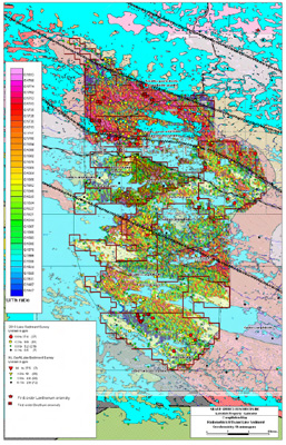
Analyses were carried out at Activation Laboratories in Ancaster, ON after sample preparation at their Goose Bay, NL preparation facility. Samples were analysed for uranium by the Delayed Neutron Counting (Actlabs - 5D) technique plus an ICP (1 E3) technique for other elements including Th and La. A compilation map showing the U/Th radiometric results and the significant lake sediment results for U, La and Be can be viewed on the company website at www.silverspruceresources.com.
The company would like to acknowledge the contribution of the Newfoundland Department of Natural Resources, under the Newfoundland Junior Exploration Assistance Program (JEAP), of up to $150,000 of matching funding for the Lobstick property exploration.
ABOUT SILVER SPRUCE
Silver Spruce is a junior exploration company originally focused on uranium in the Central Mineral Belt (CMB) and elsewhere in Labrador, Canada. With interests in more than 7,000 claims totaling more than 1750 km2 in Labrador, Silver Spruce is the second largest landholder in one of the world's premier emerging uranium districts. The company also has gold/silver projects in Mexico (Centauro) and the island of Newfoundland (Big Easy and Rambler South) and REE projects (Straits, RWM and Popes Hill) in Labrador making Silver Spruce a leading explorer in Canada and Mexico.
This release has been approved by Peter M. Dimmell, P.Geo. VP Exploration for Silver Spruce Resources Inc., a Qualified Person (QP) as defined in National Instrument 43-101.
For Further Information Contact:
SILVER SPRUCE RESOURCES
HEAD OFFICE
Gordon Barnhill, CFO & Director
Phone: 902.527.5700
Fax: 902.527.5711
E-mail: gbarnhill@silverspruceresources.com
Web: www.silverspruceresources.com
INVESTOR RELATIONS
Hugh Oswald, Ascenta Capital Partners Inc.
Phone: 604.684.4743 ext. 243
Toll Free: 1.866.684.4743 ext. 243
E-mail: hugh@ascentacapital.com
Web: www.ascentacapital.com
Neither TSX Venture Exchange nor its Regulation Services Provider (as that term is defined in the policies of the TSX Venture Exchange) accepts responsibility for the adequacy or accuracy of this release.
The Corporation seeks Safe Harbour.
Highlights
- Uranium, Uranium/Thorium and total count radiometric anomalies located in felsic volcanic units proximal to the Napes uranium showing and in intrusives associated with regional structures
- Lake sediments show:
- values to 37 ppm U3O8 hosted in felsic volcanics/tuffs, similar rocks to the Aillik Group, host for the Michelin deposit in the CMB of Labrador, good coincidence with radiometrics
- values to 248 ppm La indicating good potential for rare earth element (REE) mineralization
Sept. 14, 2010 - Bridgewater, NS - Silver Spruce Resources Inc. (TSXV: SSE) reports that it has received the results for a combined airborne radiometric / magnetic survey over the Lobstick uranium property, in west-central Labrador. The property covers anomalous government uranium in lake sediment values associated with structurally related uranium mineralization in felsic volcanic and intrusive units. The 1,062 claim (265 km2) property was acquired by option and staking in October 2009 after uranium mineralization was discovered in the felsic volcanics/tuffs by Innu prospectors Jean Pierre (Napes) Ashini and Raphael Riche during a prospecting survey supported by the company. The option agreement, to earn a 100% interest subject to a 2% NSR with a 1% buyback for $1M, totals $40,000 and 600,000 shares over 2 years. In addition, a yearly advance royalty payment, deducted from future NSR payments, of $10,000 per year, is payable from the 4th anniversary on (see News Release dated Oct. 29, 2009).
The property is located in the eastern Smallwood Reservoir area and is road accessible year round via the Lobstick Road which cuts across the area and provides access to the various dams associated with the reservoir. A powerline also extends through the area and a communication tower is located in the area of the showing. The area lies outside of the area subject to the Nunatsiavut Government moratorium on uranium mine development in lands subject to the Innu of Labrador land claim.
The two grab samples found in October 2009, carry minor disseminated pyrite and an unknown grey metallic and show yellow uranophane staining with field scintillometer readings up to 4,500 counts per second (cps). Values of 1,120 ppm (2.23 lbs/ton) and 513 ppm (1.03 lbs/ton) U3O8, and uranium/thorium ratios in the 9 to 10:1 range were obtained from the samples. Host units are the Blueberry Lake Group of Helikian age, which are mainly felsic volcanic units including tuffs. These units are coeval, or just underlie, the Sims Formation, which consists of arkose and orthoquartzite, and which is believed to be related to basin infilling in the Helikian, a similar geological setting to that of the Athabasca Basin of Saskatchewan. The geological setting is considered to be similar to that of the Michelin deposit of Fronteer Development in the Central Mineral Belt (CMB) of Labrador, in that it is uranium mineralization in a foliated felsic volcanic or tuff unit associated with shearing.
The airborne survey shows strong radiometric anomalies in all elements including uranium (U), thorium (Th) and potassium (K) and Total Count values (total of U, Th and K). Good coincidence is shown with the U anomalies and in the U in lake sediments, with many of these associated with structural features, such as regional faults, that are noted on government geological maps and the airborne magnetic survey. The anomalous areas are found throughout the property in both the felsic volcanics and intrusives.
Results have also been received for the ICP analysis for lake sediments, a total of 350, which were acquired in March. Uranium results released earlier (see News Release dated April 27, 2010) indicate that significant uranium anomalies are associated with the felsic units (both volcanic and intrusive) and in most cases, crosscutting structural features, probable faults, in the northern, central and southern parts of the property. Background values are less than 5 ppm U with 113 values greater than background and highs in the 35-37 ppm range (3 samples). The ICP results for lanthanum (La), the only rare earth analyzed for in the ICP package, indicate that there is good REE potential with with 14 first order anomalous values (greater than 144 ppm) and a high value of 248 ppm against a background of 44 ppm. Anomalous beryllium (Be) values were also noted with 17 samples giving values greater than 2 ppm, with a high of 16 ppm against a background of less than 0.5 ppm (the detection limit). Th values were background (< 20 ppm). Other elements (Mo, Cu, Pb, As) gave a few weakly elevated values which are not considered significant.
No follow up has been carried out to evaluate any of the data, either the airborne or the lake sediment results, acquired in 2010. Follow up exploration is planned for September and October, consisting of ground prospecting and geological mapping over areas easily accessible via the road network plus evaluation of the REE potential as defined by the lake sediment values.
Analyses were carried out at Activation Laboratories in Ancaster, ON after sample preparation at their Goose Bay, NL preparation facility. Samples were analysed for uranium by the Delayed Neutron Counting (Actlabs - 5D) technique plus an ICP (1 E3) technique for other elements including Th and La. A compilation map showing the U/Th radiometric results and the significant lake sediment results for U, La and Be can be viewed on the company website at www.silverspruceresources.com.
The company would like to acknowledge the contribution of the Newfoundland Department of Natural Resources, under the Newfoundland Junior Exploration Assistance Program (JEAP), of up to $150,000 of matching funding for the Lobstick property exploration.
ABOUT SILVER SPRUCE
Silver Spruce is a junior exploration company originally focused on uranium in the Central Mineral Belt (CMB) and elsewhere in Labrador, Canada. With interests in more than 7,000 claims totaling more than 1750 km2 in Labrador, Silver Spruce is the second largest landholder in one of the world's premier emerging uranium districts. The company also has gold/silver projects in Mexico (Centauro) and the island of Newfoundland (Big Easy and Rambler South) and REE projects (Straits, RWM and Popes Hill) in Labrador making Silver Spruce a leading explorer in Canada and Mexico.
This release has been approved by Peter M. Dimmell, P.Geo. VP Exploration for Silver Spruce Resources Inc., a Qualified Person (QP) as defined in National Instrument 43-101.
For Further Information Contact:
SILVER SPRUCE RESOURCES
HEAD OFFICE
Gordon Barnhill, CFO & Director
Phone: 902.527.5700
Fax: 902.527.5711
E-mail: gbarnhill@silverspruceresources.com
Web: www.silverspruceresources.com
INVESTOR RELATIONS
Hugh Oswald, Ascenta Capital Partners Inc.
Phone: 604.684.4743 ext. 243
Toll Free: 1.866.684.4743 ext. 243
E-mail: hugh@ascentacapital.com
Web: www.ascentacapital.com
Neither TSX Venture Exchange nor its Regulation Services Provider (as that term is defined in the policies of the TSX Venture Exchange) accepts responsibility for the adequacy or accuracy of this release.
The Corporation seeks Safe Harbour.