- - Results indicate anomalous REE+Y values over significant widths with narrow high grade sections
- - No high grade, vein type, material, as located in float and bedrock in the fall of 2010, was intersected
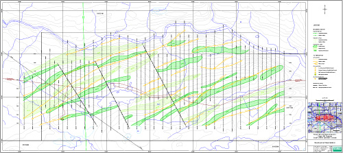
- - Geophysical compilation shows probable fault systems, parallel to the drilling direction, crosscutting the mineralized trend
March 29, 2011 - Bridgewater, NS - Silver Spruce Resources Inc. (TSXV: SSE) is pleased to announce final results from the first phase diamond drill program in the MP showing area at the Pope's Hill (PH) REE property. A total of 1120 m in 10 drill holes (PH-11- 1 to 10) tested the MP showing in the bedrock pit and another close by target on the Trans Labrador Highway (TLH), approximately 100 km from Goose Bay (see news release March 3, 2011). The first phase drilling was designed to test REE+Y mineralized bedrock and float samples from the pit, that were found in the fall of 2010, VLF-EM anomalies thought to represent shear systems, and magnetic anomalies which could reflect the variably magnetic REE+Y mineralization. The drilling tested an approximate 700 m long zone of the known 7 km mineralized trend which lies within the 100 km strike length of the full Popes Hill REE/U Trend.
Drill Results
All results have now been received. All drill holes received some sampling however it was not necessarily continuous and was guided by radioactivity (Th content), visual identification of prospective zones and magnetically anomalous areas. Results indicate anomalous REE+Y values over significant widths, with narrow high grade intersections in most holes (see attached table for a summary of results). It is significant that none of the high grade, vein type, material located in float and bedrock in the pit and along the highway which gave an average of 5.73 % TREE+Y, from the 31 samples taken over a 7 km strike length (see news release Oct. 28, 2010) was noted in the drilling. The orientation of these veins remains unknown. Eight of the holes (PH-11-1 to 6, 8,9) were drilled across the geological trend in the MP showing in the pit area. DDH PH-11-7 tested a bedrock showing and magnetic anomaly approximately 400 m to the west of the MP showing and DDH PH-11-10 was drilled down dip at the eastern end of the MP showing pit to test the potential for the higher grade veins possibly crosscutting the lithology. As noted none of the high grade veins were intersected in the drilling.
Geophysics
The final results for approximately 70 line km of magnetic and VLF-EM surveys and subsequent compilation and interpretation, on the original PH property, carried out by Abitibi Geophysics in December 2010 have also been received. The results show lithological/alteration trends in a 070 degree direction through the surveyed area. Abitibi (Berube, 2011) indicates "The MAG/VLF-EM survey over the Popes Hill property has identified a total of 7 magnetic lows, 12 combined VLF-EM conductors/ magnetic highs and 5 stand alone VLF-EM conductors. These VLF-EM and magnetic signatures suggest the presence of faults and shear zones that maybe available to REE mineralization" In addition, interpretation of the magnetic results by Abitibi (Berube, 2011) indicates three obvious crosscutting, probable fault or shear structures, trending at approximately 150/330 degrees, one of which passes through the area of the MP pit where most of the significant REE+Y bearing mineralization was found. Given these results it is possible that the REE+Y mineralized veins in the area may be related to these crosscutting structures and therefore would not have been tested by the diamond drilling. Snow conditions made it impossible to map the pit prior to the start of the drilling to define the orientation of the veins and no follow up has been carried out to evaluate any of the other geophysical targets or crosscutting structures on the original property.
The diamond drilling has defined an area of anomalous REE+Y mineralization hosted in the gneissic units in the Popes Hill area. Wide zones, up to 140 m of > 0.1 % REE+Y mineralization has been noted with at least 4 holes giving widths in the 50 m range. Narrow (0.1-0.3 m) zones of higher grade REE+Y values in the 1 to 6 % range are also found throughout most of the drill holes. In addition strong Zr values generally > 1,000 ppm (0.1 %) were noted over wide intervals associated with the REE mineralization. The vein type, high grade, REE+Y mineralization sampled in the prospecting survey in the fall of 2010 was not intersected in this drilling although it is noted in the MP showing on surface and in samples derived from the pit, scattered along the TLH. The geophysical interpretation indicates that cross cutting faults/shears are noted, with one of these cutting the geological units in the MP showing area. It is possible that the high grade mineralization located in the pit and in other locations over the 7 km strike of the original PH trend is trending at 330 degrees essentially parallel to the drilling direction. It is possible that the vein mineralization could have been remobilized from the surrounding anomalous REE bearing units and then concentrated along the crosscutting shears / faults. This possibility will be tested by exploration planned for the spring / summer of 2011.
Planned work
Regional exploration including airborne radiometrics, magnetics and VLF-EM will evaluate the PH belt for REEs and U in the summer of 2011. Detailed exploration including gridding, prospecting, geological mapping, geochemistry and ground geophysics will begin on the original PH group and the MRT property as soon as snow conditions permit most likely in May.
The Pope's Hill REE/U trend, where SSE has interests in over 2,200 claims, 1,700 of which are 100% owned, extends over a 100 km strike length, and covers government La/Ce lake sediments which indicate an anomalous REE trend and where no REE/U exploration has been carried out. Uranium potential is also shown, at least in the eastern portion of the belt, where the recently optioned MRT property gave U values up to 0.8 % (News Release Feb. 17/11). .
Drill core was cut in half using a diamond core saw, with one half sent for analysis and the other half retained. Samples were submitted to the Activation Prep laboratory in Goose Bay where they are prepped and then sent to their laboratory in Ancaster, ON for analysis using a Code 8 REE package which uses a lithium borate fusion and then analysis by either ICP or ICP-MS. Values were checked by Actlabs using internal standards.
A diamond drill plan map, a summary of the drill holes , the geophysical compilation map and other information on the Pope's Hill REE Project and our other REE projects can be found on the Silver Spruce website at: www.silverspruceresources.com.
ABOUT SILVER SPRUCE
Silver Spruce is a junior exploration company originally focused on uranium in the Central Mineral Belt (CMB) and elsewhere in Labrador, Canada. With interests in more than 4,000 claims totaling more than 1,000 square kilometers in Labrador, Silver Spruce is one of the largest landholders in one of the world's premier emerging uranium and REE districts. The company also has rare earth element (REE) properties in Labrador - Pope's Hill, RWM and the Straits and gold/silver projects -- Big Easy and Rambler S, on the island of Newfoundland.
This release has been approved by Peter Dimmell, P.Geo., Vice President of Exploration, Silver Spruce Resources Inc., who is a Qualified Person (QP) as defined in National Instrument 43-101.
For Further Information, Contact:
Silver Spruce Resources - Head Office
Gordon Barnhill, CFO & Director
Phone: 902.527.5700
Fax: 902.527.5711
Email: gbarnhill@silverspruceresources.com
Web: www.silverspruceresources.com
Investor Relations
Hugh Oswald, Ascenta Capital Partners Inc.
Phone: 604.684.4743 ext. 243
Toll Free: 1.866.68.4743 ext. 243
Email: hugh@ascentacapital.com
Web: www.ascentacapital.com
The Corporation seeks Safe Harbour.
| POPES HILL PROPERTY Significant REE+Y values - 2011 DDH |
||||
| DDH NO. | FROM | TO | TOTAL (m) | TREE+Y % |
| PH-11-01 | 56.6 | 67.6 | 11.0 | 0.26 |
| incl. | 62.2 | 62.3 | 0.1 | 2.94 |
| incl. | 66 | 66.1 | 0.1 | 4.79 |
| and | 90.6 | 103.4 | 12.8 | 0.20 |
| incl. | 92.1 | 93.6 | 1.5 | 0.76 |
| PH-11-02 | 24 | 35.8 | 11.8 | 0.2 |
| incl. | 24 | 24.2 | 0.2 | 1.39 |
| incl. | 30.6 | 32.6 | 2 | 0.43 |
| and | 103 | 113.2 | 10.2 | 0.16 |
| incl. | 104.1 | 104.2 | 0.1 | 3.57 |
| incl. | 109.4 | 109.5 | 0.1 | 2.44 |
| and | 125 | 131 | 6 | 0.15 |
| PH-11-03 | 2.4 | 59.5 | 57.1 | 0.15 |
| incl. | 2.4 | 16.3 | 13.9 | 0.22 |
| incl. | 7 | 36.5 | 29.5 | 0.2 |
| incl. | 12.5 | 13.5 | 1 | 0.99 |
| incl. | 15.9 | 16.3 | 0.4 | 1.69 |
| incl. | 15.9 | 22 | 6.1 | 0.39 |
| incl. | 21.8 | 22 | 0.2 | 2.72 |
| PH-11-04 | 22 | 29.3 | 7.3 | 0.24 |
| incl. | 25.6 | 29.3 | 3.7 | 0.36 |
| incl. | 25.6 | 25.7 | 0.1 | 3.74 |
| and | 65.8 | 68.4 | 2.6 | 0.74 |
| incl. | 66.5 | 68.4 | 1.9 | 0.98 |
| incl. | 66.5 | 67 | 0.5 | 2.6 |
| incl. | 66.7 | 66.8 | 0.1 | 10.56 |
| and | 53.8 | 65.8 | 12 | 0.18 |
| PH-11-05 | 8.3 | 55.7 | 47.4 | 0.16 |
| incl. | 8.3 | 8.5 | 0.2 | 5.26 |
| incl. | 16.1 | 16.2 | 0.1 | 1.41 |
| incl. | 46.5 | 46.6 | 0.1 | 3.64 |
| incl. | 52.5 | 52.6 | 0.1 | 6.96 |
| PH-11-06 | 39 | 53.8 | 14.8 | 0.14 |
| incl. | 42.9 | 43 | 0.1 | 2.34 |
| PH-11-07 | 7.5 | 7.7 | 0.2 | 0.56 |
| PH-11-08 | 5.0 | 145.0 | 140.0 | 0.11 |
| incl. | 5.0 | 60.0 | 55.0 | 0.15 |
| incl. | 46.5 | 46.7 | 0.2 | 1.22 |
| and | 47.9 | 48.2 | 0.3 | 1.16 |
| PH-11-09 | 6.0 | 58.0 | 52.0 | 0.11 |
| incl. | 7.4 | 7.6 | 0.2 | 4.36 |
| and | 48.3 | 50.7 | 2.4 | 0.41 |
| PH-11-10 | 39.6 | 43.2 | 3.6 | 0.11 |
| and | 49.5 | 53.0 | 3.5 | 0.21 |
| and | 59.8 | 77.1 | 17.3 | 0.17 |