December 8, 2009
- wide zones (> 50 m) of anomalous gold (> 100 ppb) and silver (> 5 ppm) values with associated mercury, arsenic and antimony
- associated alteration composed of silicification and decalcification of the rock units
- highly anomalous mercury values indicate deeper drilling is required to reach the more favorable areas of the system, where bonanza grade mineralization may occur.
December 8, 2009 - Bridgewater, NS - Silver Spruce Resources Inc. (TSXV: SSE) is pleased to provide the diamond drilling results for the area to the north of the Centauro mesa, drilled as part of the 2nd Phase drill program carried out in August and September 2009. Two areas were drilled - to the north of Centauro mesa in the Line 6 area, where strong quartz veining carrying arsenic and antimony mineralization is noted and to the northeast, on the east side of the mesa, where the extensive silica breccias zones are found and where the gold/silver values in CEN-08-10 (see below) were located. Drill results from the northeast area are pending and will be reported when received and compiled.
Results of the 2008 drilling (3,960 metres in 14 holes - CEN-08-1 to 14) which tested the Centauro alteration zone over a 2.3 kilometre strike length and 1 kilometre width were reported in late 2008 and early 2009 (see news releases - Oct. 7 and Dec. 9, 2008 and Jan. 20, 2009). The highlight was a gold/silver intersection of 7.5 m at 1.93 g/t Au and 64 g/t Ag at the top of hole CEN-08-10, in a 92.1 metre zone, from 3 to 95.1 m, which assayed 237 ppb Au and 8.4 g/t Ag. The hole collared in mineralization so the full width of the intersection remains unknown as does its orientation and true width. Acanthite, a silver-bearing mineral, and native gold were identified (news release Dec. 9, 2008). The gold / silver values are associated with the strong silicification in the silica breccia better defined by 2009 field work which appears to be dipping to the east / northeast, basinward.
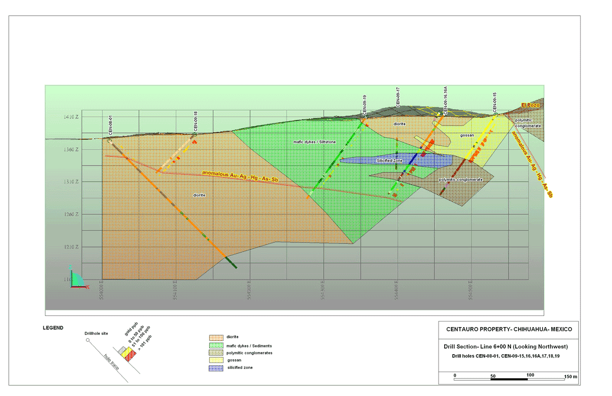
Work in 2009, prior to the drilling, consisted of relogging the 2008 core, geological mapping, field checking and geological compilation. This resulted in a better understanding of the geological setting of the alteration package and mineralized zones and defined areas requiring further diamond drilling (News release July 7, 2009). A total of 1,864.5 meters were drilled in the 2009 program, 705 m in six drill holes (CEN-09-15,16,16A,17,18,19) in the north area on Line 6 (reported on here) and 1,159.5 m in nine holes (CEN-09-20,21,22,23,24,25,26,26A,27) in the northeast area.
The only hole in the north area, prior to the 2009 drilling, was CEN-08-1 which was drilled on L 6 further to the west. In the 2009 program, drill-holes CEN-09-15,16,16A,18 and 19 were drilled to the southwest (240 degrees), as a fence along Line 6, while CEN-09-17 was drilled perpendicular to the line to evaluate a possible fault (see section on website). The drill-holes targeted a wide (600 x 200 m) area anomalous in gold-silver-mercury-arsenic-antimony. CEN-09-15, collared at the base of El Pozo hill, cut 82 meters of a highly sheared, gossanous unit before passing into unaltered calcareous polymitic conglomerate. CEN-09-16, collared 100 to the southwest of hole #15, was lost in bad ground and was re-started as CEN-09-16A a few meters from the original collar. The upper portion of the hole, from 0 to 36 m, was sheared to gossanous diorite after which a wide section, from 36 to 148 m, of sheared, decalcified, and locally silicified, conglomerate and mafic dikes were intersected. Sulphides, pyrite and arsenopyrite, averaging 5 to 7%, are disseminated throughout the zone. Local silicified zones are vuggy with botryoidal quartz carrying realgar, an arsenic mineral. CEN-09-17 intersected 94 meters of sheared, sulphide bearing intrusive before intersecting fresh polymictic conglomerate carrying weak decalcified zones associated with sheared sections. CEN-09-18 intersected 84 meters of highly sheared, locally silicified, sulphide bearing (pyrite and arsenopyrite), diorite and mafic dikes before being lost in bad ground, which prevented further drilling. CEN-09-19 cut similar units and was lost at 156 meters also in bad ground.
Analytical results from all holes gave wide zones of anomalous gold/silver/mercury/arsenic/antimony associated with alteration including decalcification and silicification associated with shearing, which is sometimes gossanized. The strong, pervasive mercury geochemical signature encountered in all holes suggests that the drilling, which tested to a maximum of 100 m vertical, is too high in the system for "bonanza style" gold-silver epithermal veins and deeper holes are required to properly test the system.
Results from the 2009 drilling will be combined with 2008 drill results to create a more accurate geological picture of the area in order to try to vector in on the source of the strong epithermal fluid flow. A summary of analytical results for the 2009 holes which tested the north area in the vicinity of L 6, are provided in Table 1 below.
TABLE 1 |
|||||||||
Hole |
From |
To |
Length |
Au |
Ag |
Hg |
As |
Sb |
Ba |
CEN-09-15 |
12 |
82.9 |
70.9 |
145 |
6.5 |
21853 |
1098 |
202 |
695 |
CEN-09-16A |
36 |
148.4 |
112.4 |
125 |
7.5 |
20008 |
968 |
124 |
2911 |
CEN-09-17 |
27 |
37.5 |
10.5 |
50 |
4.7 |
9374 |
907 |
70 |
559 |
" |
104 |
114 |
10 |
42 |
2.7 |
7193 |
395 |
44 |
1856 |
CEN-09-18 |
6 |
84 |
78 |
71 |
5.3 |
13167 |
2241 |
95 |
735 |
CEN-09-19 |
6 |
90 |
84 |
51 |
5.9 |
8123 |
1216 |
147 |
1092 |
" |
96 |
129 |
33 |
67 |
5.9 |
14323 |
1439 |
104 |
640 |
Dr. Greg Arehart, the Head of the Geological Sciences and Engineering Department at the University of Nevada in Reno, and a recognized expert in epithermal and Carlin-type gold deposits, has visited the Centauro Property and, as a consultant to Silver Spruce, has been provided with all data from the exploratio. He comments:
"The anomalous trace element values from many holes coupled with the elevated precious metals is a good indication that the system is large and robust. Indications are that we are still above the main precious metal zone, because of the very high Hg values with somewhat lower As, Sb and precious metals. This pattern suggests that minimal erosion has occurred since metal deposition. The precious metal horizon is likely to be several hundred meters below the paleo-water table."
About the Centauro Property
The Centauro property is a block of eight claims (3,088 hectares), located in the southern part of Chihuahua State, Mexico. It is just north of the Durango State boundary and lies approximately 25 kilometres to the west of Highway 45, Mexico's main north-south highway. The property is subject to an option agreement with a Mexican geologist, whereby Silver Spruce can earn a 100% interest in the property subject to a 3% NSR with a 2% buyback for US$2 million. Compilation maps showing the drill locations, and geology plus pictures and the QA / QC protocols can be viewed on the company website www.silverspruceresources.com.
All analyses were carried out at the Activation Laboratories (Actlabs) facility in Ancaster, Ontario. The drill core samples were sawed, under company supervision, at the field office in Jiminez, Chihuahua State. One half of the core was sampled, mostly at one to three meter intervals, and sent to Minerales Laboratory S.A. de C.V. in Mazatlan for sample preparation, as approved by Actlabs. Pulps were forwarded to Actlabs in Ancaster for analysis. The samples were analyzed by fire assay (one assay tonne) for gold plus a 30 element ICP technique for other elements and cold vapour FIMS for Hg. Every twenty-fifth sample was also analyzed by fire assay (one assay tonne) for gold and an atomic absorption technique for silver at the Minerales Laboratory in Mazatlan for quality assurance/quality control (QA/QC) purposes. A QA/QC program is in place to increase confidence in the results generated.
ABOUT SILVER SPRUCE
Silver Spruce is a junior exploration company originally focused on uranium in the Central Mineral Belt (CMB) and elsewhere in Labrador, Canada. With interests in more than 6,000 claims totaling more than 1,500 square kilometers in Labrador, Silver Spruce is the second largest landholder in one of the world's premier emerging uranium districts. The company also has gold/silver projects in Mexico and the island of Newfoundland, and base metal projects in central and western Newfoundland making Silver Spruce a leading explorer in Canada and Mexico.
This release has been approved by Peter Dimmell, P.Geo., Vice President of Exploration, Silver Spruce Resources Inc., who is a Qualified Person (QP) as defined in National Instrument 43-101.
For Further Information Contact:
SILVER SPRUCE RESOURCES
HEAD OFFICE
Gordon Barnhill, CFO & Director
Phone: 902.527.5700
Fax: 902.527.5711
E-mail: gbarnhill@silverspruceresources.com
Web: www.silverspruceresources.com
INVESTOR RELATIONS
Hugh Oswald, Ascenta Capital Partners Inc.
Phone: 604.684.4743 ext. 243
Toll Free: 1.866.684.4743 ext. 243
E-mail: hugh@ascentacapital.com
Web: www.ascentacapital.com
The Corporation seeks Safe Harbour.
Click to Enlarge