- Rock samples to 8 per cent total rare earth oxides (TREO), associated with significant stream sediment anomalies
- 18 samples with TREO values > 0.5 per cent, with Nd2O3 averaging 0.34 per cent in these samples
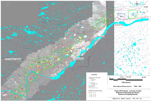
- REE stream sediment anomalies in a number of locations along the PH trend
Bridgewater NS, Canada -- January 10, 2012 / CNW - Silver Spruce Resources Inc. (TSXV:SSE) is pleased to provide the results for regional exploration on the road-accessible Pope's Hill, 100 per cent owned, Rare Earth Element (REE) property on the Trans-Labrador Highway (TLH) in southern Labrador, 40 to 100 km to the west of Happy Valley Goose Bay (HVGB).
Note that Silver Spruce is now reporting rare earth oxide (REO) values whereas previously (2011 and earlier) all results were reported as rare earth elements (REE) which give lower absolute values than REO.
Exploration consisted of stream sediment geochemical sampling and prospecting, and was completed in late September, with a total of 539 stream sediment samples taken at approximate 300 m intervals on streams draining the prospective areas to the north and west of the Churchill River over the 100 per cent owned properties. In addition, a number of radioactive zones were noted and a total of 91 rock samples were taken. The stream sediment samples were analyzed for a suite of eight REE, four light rare earths (LREE) including La, Ce, Nd, Sm and four heavy rare earths (HREE) including Eu,Tb, Yb, and Lu. The analytical data has been translated to rare earth oxides (REO), both light (LREO) and heavy (HREO). Results for concurrent regional surveys on the 100 per cent owned MRT property and the 50/50 Pope's Hill JV with Great Western Minerals Group along the Pope's Hill trend will be reported separately.
The mean for the stream sediment samples was 378 ppm giving a second order anomaly at > 686 ppm TREO. The highest priority area, which has the highest value (1380 ppm) from the survey and three values > 900 ppm TREO, is located to the southwest of the TLH to the north of Gull Island in the Pope's Hill area, on Licence 18104M. This is the same area where two rock samples gave 8.2 per cent (float) and 7 per cent (o/c) TREO. Another significant stream sediment anomaly, with values up to 726 ppm and 6 values > 600 ppm TREO, was located to the west of Upper Brook, to the north of the TLH, on Licence 18102M coincident with a rock sample in o/c that gave a value of 3.3 per cent TREO. TREO values in the 1-4 per cent range, with many others from 0.1-0.3 per cent, were noted along the TLH to the west of the original group on Licence 18101M -- these may be related to pegmatites. Two samples along the Pinus River to the northeast of the MP trend gave values of 3.2 per cent and 1.9 per cent TREO -- these may indicate a strike extension of the MP trend mineralization. All samples are LREO enriched with 18 samples giving TREO values > 0.5 per cent, with an average of 0.34 per cent Nd2O3. The samples were generally low in HREO, giving values from 1--5 per cent of the TREO.
A number of significant anomalous stream sediments without backup rock samples were also found as follows: four areas on Licences 18104-106M in the SW portion of the property, both to the east and west of the Churchill River and to the south of the TLH (these areas are not road accessible); in Licence 18108M between Upper and Lower Brooks, to the north of the TLH; and on Licence 18564M to the northwest of the MRT property, to the north of the TLH, approximately 40 km from HVGB (see map on website). All the stream sediments are LREO enriched with HREO averaging 6-12 per cent of the TREO in samples > 600 ppm and in the 2-12 per cent range, but mainly 3-5 per cent in samples with values < 600 ppm.
Further compilation of all data is ongoing and it will be released as it is completed. Follow up will be carried out in the spring / summer of 2012 once snow conditions permit.
The samples were transported to Activation Labs' preparation facility in Goose Bay by SSE personnel, then shipped to their laboratory in Ancaster, ON for analysis using their 1 D enhanced INAA technique for stream sediments and their 8 REE technique for the rock samples. The laboratory uses internal standards to check the analyses and blanks are included in each sample batch. Plan maps of the properties with the stream sediment and regional rock sample results; the airborne thorium radiometric and magnetic data, plus pictures of the area; as well as the showings and some of the higher grade samples from the MP trend area, are available on the Silver Spruce website at www.silverspruceresources.com.
This release has been approved by Peter M. Dimmell, P.Geo. President and CEO of Silver Spruce Resources Inc., who is a Qualified Person (QP) in NL and ON as defined in National Instrument 43-101.
About Silver Spruce Resources Inc.
Silver Spruce is a diversified junior exploration company with a portfolio of rare earth (Pope's Hill, Pope's Hill JV (with Great Western Minerals Group), MRT, RWM and the Straits), gold and silver (Big Easy), and uranium (CMBJV, Snegamook, Double Mer, Mount Benedict), projects in Newfoundland and Labrador. With interests in more than 4,000 claims totalling more than 1,000 square kilometres in Labrador, Silver Spruce is one of the largest landholders in one of the world's premier emerging rare earth and uranium districts. For more information go to www.silverspruceresources.com
The TSX Venture Exchange or its Regulation Services Provider (as that term is defined in the policies of the TSX Venture Exchange) does not accept responsibility for the adequacy or accuracy of this release. The company seeks Safe Harbour.
For further information contact:
Gordon Barnhill, CFO & Director
Silver Spruce Resources Inc.
Phone: 902.527.5700
Fax: 902.527.5711
gbarnhill@silverspruceresources.com
For investor & media relations contact:
Paul Snow
Pilot Communications Inc.
Phone: 709.753.0794 ext 31
Fax: 709.753.0795
psnow@pilotcom.ca