December 1, 2009
Highlights
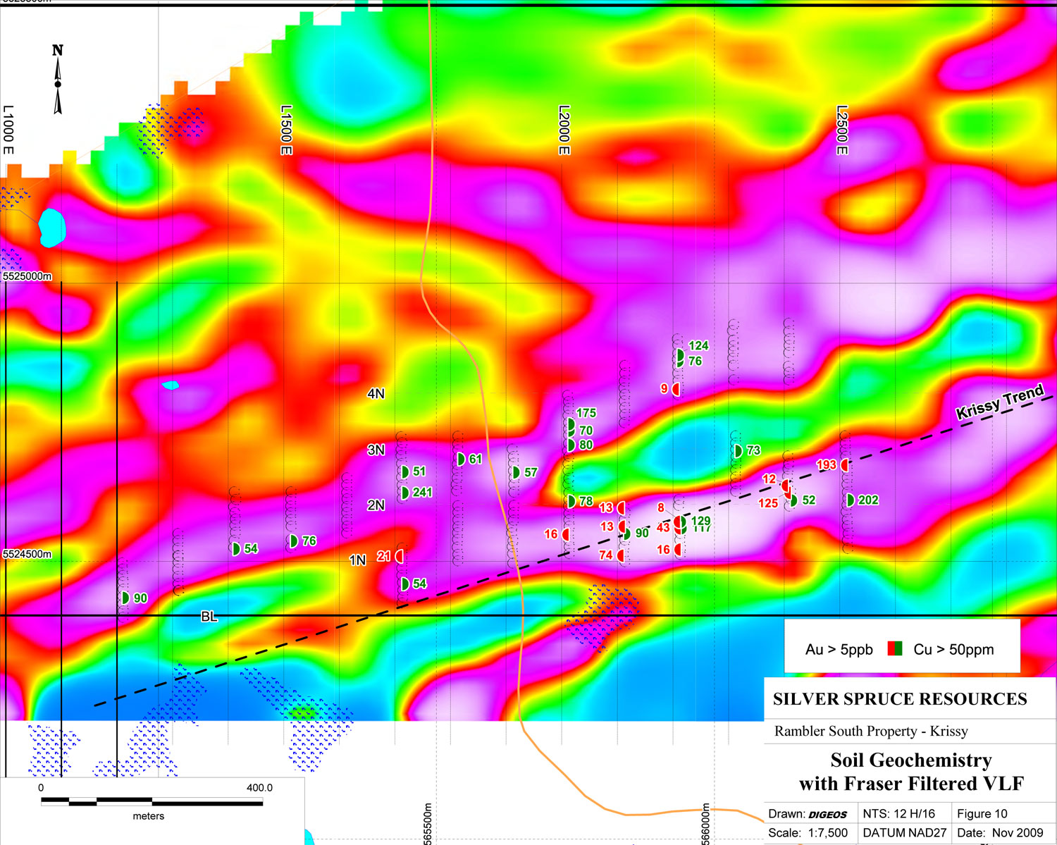
- Gold in soil values up to 193 ppb on Krissy trend - untested
- check assays from diamond drilling confirm gold values -- SB and Krissy trends
December 1, 2009 - Bridgewater, NS - Silver Spruce Resources Inc. (TSXV: SSE) is pleased to release the results of soil geochemical and prospecting surveys and check assay results of drill core on the Rambler South property, located on the Baie Verte peninsula of north central Newfoundland. The company also reports on the results of further sampling on the Lobstick uranium property and the termination of the option on the 20th Brook base metal property.
Rambler South Property
The Rambler South property totals 56 claims (1,400 ha) and was optioned from Northeast Exploration Services, Krinor Resources Inc. and Peter Dimmell (PMD). Terms of the option to earn a 100% interest subject to a 2.5% NSR, with a 1.0% buyback for $1.5 M, for a total payment of $95,000, issuance of 1.05M shares and a work commitment of $500,000 by the end of the second year. In addition, a yearly advance royalty payment, deducted from future NSR payments, of $10,000 per year, is payable from the 4th anniversary on.
The soil geochemical survey targeted the Krissy shear and parallel structures as defined by VLF-EM (see map on website). Gold in soil anomalies were confined to the Krissy shear zone, over an 800 m strike length, from 17 E, 1+12.5 N, up ice from the visible gold bearing Krissy boulder, to 25 E, 2+75 N. Background is < 5 ppb Au and anomalous gold values were from 16 to 193 ppb Au, with the two highest values, 125 and 193 ppb on Lines 24 and 25 E respectively, in an area that has received no exploration follow up and which remains open to the east. The highest value in the vicinity of the Trench 2 area, site of the 2009 drilling, was 74 ppb on L 21 E. Copper background values were < 10 ppm. Good coincidence of copper with gold was noted on the Krissy shear, with the Trench 2 area (22 E) giving values of 117 and 129 ppm, 21 E - 90 ppm and 25 E - 202 ppm Cu. Anomalous copper values were also located along a linear VLF-EM anomaly to the north of the Krissy shear, extending over 1 kilometre strike length from 12 to 22 E, with a number of values > 50 ppm and highest values, 241 ppm on 17 E, 175 ppm on 20 E and 124 ppm on 22 E. No significant gold values were associated. This area has never been prospected or otherwise evaluated and the source remains unexplained.
VLF-EM Fraser Filter anomalies defined in a survey carried out in 1988, were used to target the soil geochemistry. Detailed (12.5 m interval) soil samples were taken over the linear anomalies on the southern part of the Krissy grid, on Lines 12-25 E. Samples were analyzed for Au by fire assay and by an ICP technique for other elements including base metals and gold indicator elements at Eastern Analytical Laboratories in Springdale, a recognized local laboratory.
Seven (7) grab samples were taken from the Uncle Ross showing on Line 10 E on the Krissy grid during a due diligence visit in October. Results indicate that weak gold mineralization is present in the silicified/sericitized alteration zone over a 25 m2 area. Values from 27 to 435 ppb Au, with 4 > 50 ppb Au were located. Associated copper values were background (< 15 ppm), to 636 ppm with two values > 200 ppm Cu. All other elements gave ND to weakly anomalous values. The area lies on the Krissy Trend, 1.2 km to the west of Trench 2 (on L 22 E).
The drill program was designed to test the strong gold in till anomaly in the South Brook area and the Krissy, shear hosted, gold zone. The drill program ended with a total of 542 m in 7 holes completed (RS-09-1 to 5 and KT-09-1, 2) (News releases dated July 16, Sept. 10, Sept. 30, and Oct. 22, 2009). Gold intersections up to 1.4 g/t over 17.5 m, including 9.99 g/T over 0.7 m, in RS-09-3 were located, in the SB drilling, hosted in a quartz/chlorite breccia, with recrystallized quartz fragments, cemented by fine grained chlorite carrying disseminated pyrite and minor chalcopyrite. Overburden Drilling Management work indicates that the gold in the SB till anomaly is fine grained (generally 20-30 micron) free gold with a strong chlorite association. The zone has been traced over a 100 m strike length in three drill holes, remaining open to depth and to the northeast along trend.
Gold mineralization, including visible gold, at the Krissy zone is associated with sulphide rich quartz veins emplaced along a shear zone, up to 5 m in width, related to the intrusion of linear quartz porphyry bodies. Significant values from the zone include: 12.5 g/t / 1.5 m in a channel sample in the trench 2 area near L 22 E, and 2.75 g/t over 1.65 m, including 6.85 g/T over 0.51 m, in DDH KT-09-1. The Krissy boulder, an approximate 500 lb boulder of recrystallized quartz with pyrite and visible gold in an altered/sheared sericitic volcanic or porphyry unit, located on L 17 E, 500 m to the west of the Trench 2 area and across the ice direction, remains unsourced.
A total of 13 check analyses were carried out on samples of low, moderate and higher grade values from the diamond drill core from both the Krissy and SB trends. These results confirm that gold is present in the system and is most likely free gold based on the variances in the sample results, with some samples giving higher values and some giving lower values, than the original analyses. Metallics analyses for three higher grade samples remain pending.
Note: highest values bolded; na - not assayed
Lobstick Property
The company reports the results of follow up prospecting in the Lobstick area of Labrador where two significant uranium values, of 1,120 ppm (2.23 lbs / ton) and 513 ppm (1.03 lbs / ton) U3O8, were located by Innu prospectors allied with the company in October (News release -- Oct. 29, 2009). A due diligence field visit to the showing, carried out in mid October when snow conditions prevented an extensive evaluation, confirmed the anomalous scintillometer readings at the site. A single, 1 m long, channel sample taken from the felsic unit, generally on strike of, and approximately 20 m to the east, of the original anomalous grab samples, gave 53 ppm U. Seven grab samples collected from road cuts 2 to 5 kilometres to the north of the original discovery, where total count scintillometer values in the 250 to 500 cps range were located, gave values from ND (< 10 ppm) to 149 ppm U. More work is required to evaluate the showing and the regional potential of the area.
20th Brook Property
The company also announces that it has terminated the option on the 20th Brook Zn-Pb property near Stephenville in western Newfoundland. While trenching results gave some significant values in Pb and Zn, they were not considered to be strong enough to warrant further work at this time, when the company is primarily focusing on gold, especially the Rambler South property in NL and the Centauro project in Chihuahua, MX. Assays from Centauro remain pending due to a backlog of samples this fall -- they will be reported when they are received.
Drill core was sawed in half using a diamond saw, by SSE personnel, with one half of the core retained and the other half sent to Eastern Analytical Laboratories in Springdale, NL to be analyzed for Au by fire assay (1/2 assay tonne) plus ICP-11 for other elements. Check assays were performed on both pulps and rejects from the original core samples at Accurassay Laboratories in Thunder Bay, ON. Uranium analyses on rocks were performed using an ICP technique at Actlabs in Ancaster, ON. Data on the Rambler South property, including the soil geochemical results from the Krissy Trend, compilation maps, a plan map of the 2009 drilling, plus pictures from the area, and a compilation map of the Lobstick area, are provided on the Silver Spruce website at silverspruceresources.com.
ABOUT SILVER SPRUCE
Silver Spruce is a junior exploration company with advanced gold/silver projects in Mexico and the island of Newfoundland, and base metal projects in central and western Newfoundland. The company was originally focused on uranium in the Central Mineral Belt (CMB) and elsewhere in Labrador, Canada and with continued interests in more than 6,000 claims totaling more than 1,500 square kilometers in Labrador, Silver Spruce remains the second largest landholder in one of the world's premier emerging uranium districts. This diversity makes Silver Spruce a leading explorer in Canada and Mexico.
This release has been approved by Guy Mac Gillivray, P.Geo., Senior Geologist for Silver Spruce Resources Inc., who is a Qualified Person (QP) as defined in National Instrument 43-101.
For Further Information Contact:
SILVER SPRUCE RESOURCES
HEAD OFFICE
Gordon Barnhill, CFO & Director
Phone: 902.527.5700
Fax: 902.527.5711
E-mail: gbarnhill@silverspruceresources.com
Web: www.silverspruceresources.com
INVESTOR RELATIONS
Hugh Oswald, Ascenta Capital Partners Inc.
Phone: 604.684.4743 ext. 243
Toll Free: 1.866.684.4743 ext. 243
E-mail: hugh@ascentacapital.com
Web: www.ascentacapital.com
Neither TSX Venture Exchange nor its Regulation Services Provider (as that term is defined in the policies of the TSX Venture Exchange) accepts responsibility for the adequacy or accuracy of this release. The company seeks Safe Harbour.
- Gold in soil values up to 193 ppb on Krissy trend - untested
- check assays from diamond drilling confirm gold values -- SB and Krissy trends
December 1, 2009 - Bridgewater, NS - Silver Spruce Resources Inc. (TSXV: SSE) is pleased to release the results of soil geochemical and prospecting surveys and check assay results of drill core on the Rambler South property, located on the Baie Verte peninsula of north central Newfoundland. The company also reports on the results of further sampling on the Lobstick uranium property and the termination of the option on the 20th Brook base metal property.
Rambler South Property
The Rambler South property totals 56 claims (1,400 ha) and was optioned from Northeast Exploration Services, Krinor Resources Inc. and Peter Dimmell (PMD). Terms of the option to earn a 100% interest subject to a 2.5% NSR, with a 1.0% buyback for $1.5 M, for a total payment of $95,000, issuance of 1.05M shares and a work commitment of $500,000 by the end of the second year. In addition, a yearly advance royalty payment, deducted from future NSR payments, of $10,000 per year, is payable from the 4th anniversary on.
The soil geochemical survey targeted the Krissy shear and parallel structures as defined by VLF-EM (see map on website). Gold in soil anomalies were confined to the Krissy shear zone, over an 800 m strike length, from 17 E, 1+12.5 N, up ice from the visible gold bearing Krissy boulder, to 25 E, 2+75 N. Background is < 5 ppb Au and anomalous gold values were from 16 to 193 ppb Au, with the two highest values, 125 and 193 ppb on Lines 24 and 25 E respectively, in an area that has received no exploration follow up and which remains open to the east. The highest value in the vicinity of the Trench 2 area, site of the 2009 drilling, was 74 ppb on L 21 E. Copper background values were < 10 ppm. Good coincidence of copper with gold was noted on the Krissy shear, with the Trench 2 area (22 E) giving values of 117 and 129 ppm, 21 E - 90 ppm and 25 E - 202 ppm Cu. Anomalous copper values were also located along a linear VLF-EM anomaly to the north of the Krissy shear, extending over 1 kilometre strike length from 12 to 22 E, with a number of values > 50 ppm and highest values, 241 ppm on 17 E, 175 ppm on 20 E and 124 ppm on 22 E. No significant gold values were associated. This area has never been prospected or otherwise evaluated and the source remains unexplained.
VLF-EM Fraser Filter anomalies defined in a survey carried out in 1988, were used to target the soil geochemistry. Detailed (12.5 m interval) soil samples were taken over the linear anomalies on the southern part of the Krissy grid, on Lines 12-25 E. Samples were analyzed for Au by fire assay and by an ICP technique for other elements including base metals and gold indicator elements at Eastern Analytical Laboratories in Springdale, a recognized local laboratory.
Seven (7) grab samples were taken from the Uncle Ross showing on Line 10 E on the Krissy grid during a due diligence visit in October. Results indicate that weak gold mineralization is present in the silicified/sericitized alteration zone over a 25 m2 area. Values from 27 to 435 ppb Au, with 4 > 50 ppb Au were located. Associated copper values were background (< 15 ppm), to 636 ppm with two values > 200 ppm Cu. All other elements gave ND to weakly anomalous values. The area lies on the Krissy Trend, 1.2 km to the west of Trench 2 (on L 22 E).
The drill program was designed to test the strong gold in till anomaly in the South Brook area and the Krissy, shear hosted, gold zone. The drill program ended with a total of 542 m in 7 holes completed (RS-09-1 to 5 and KT-09-1, 2) (News releases dated July 16, Sept. 10, Sept. 30, and Oct. 22, 2009). Gold intersections up to 1.4 g/t over 17.5 m, including 9.99 g/T over 0.7 m, in RS-09-3 were located, in the SB drilling, hosted in a quartz/chlorite breccia, with recrystallized quartz fragments, cemented by fine grained chlorite carrying disseminated pyrite and minor chalcopyrite. Overburden Drilling Management work indicates that the gold in the SB till anomaly is fine grained (generally 20-30 micron) free gold with a strong chlorite association. The zone has been traced over a 100 m strike length in three drill holes, remaining open to depth and to the northeast along trend.
Gold mineralization, including visible gold, at the Krissy zone is associated with sulphide rich quartz veins emplaced along a shear zone, up to 5 m in width, related to the intrusion of linear quartz porphyry bodies. Significant values from the zone include: 12.5 g/t / 1.5 m in a channel sample in the trench 2 area near L 22 E, and 2.75 g/t over 1.65 m, including 6.85 g/T over 0.51 m, in DDH KT-09-1. The Krissy boulder, an approximate 500 lb boulder of recrystallized quartz with pyrite and visible gold in an altered/sheared sericitic volcanic or porphyry unit, located on L 17 E, 500 m to the west of the Trench 2 area and across the ice direction, remains unsourced.
A total of 13 check analyses were carried out on samples of low, moderate and higher grade values from the diamond drill core from both the Krissy and SB trends. These results confirm that gold is present in the system and is most likely free gold based on the variances in the sample results, with some samples giving higher values and some giving lower values, than the original analyses. Metallics analyses for three higher grade samples remain pending.
CHECK ASSAYS - DIAMOND DRILLING - 2009
| Eastern Analytical | Accurassay | |||
| Original analyses | Checks - pulps | Checks - rejects | Checks - rejects | |
| 1st cut | Duplicate | |||
| Sample # | ppb Au | ppb Au | ppb Au | ppb Au |
| 42018 | 70 | 41 | na | na |
| 42042 | 5868 | 5092 | 5147 | na |
| 42089 | 25 | 19 | na | na |
| 42103 | 428 | 417 | 511 | na |
| 42132 | 63 | 50 | na | na |
| 42150 | 655 | 621 | 596 | na |
| 42208 | 3596 | 4114 | 4515 | 4618 |
| 42209 | 1120 | 1151 | na | na |
| 42258 | 29 | 46 | na | na |
| 42278 | 352 | 1127 | na | na |
| 42290 | 298 | 32 | na | na |
| 42314 | 1564 | 2061 | na | na |
| 42349 | 462 | 407 | na | na |
Note: highest values bolded; na - not assayed
Lobstick Property
The company reports the results of follow up prospecting in the Lobstick area of Labrador where two significant uranium values, of 1,120 ppm (2.23 lbs / ton) and 513 ppm (1.03 lbs / ton) U3O8, were located by Innu prospectors allied with the company in October (News release -- Oct. 29, 2009). A due diligence field visit to the showing, carried out in mid October when snow conditions prevented an extensive evaluation, confirmed the anomalous scintillometer readings at the site. A single, 1 m long, channel sample taken from the felsic unit, generally on strike of, and approximately 20 m to the east, of the original anomalous grab samples, gave 53 ppm U. Seven grab samples collected from road cuts 2 to 5 kilometres to the north of the original discovery, where total count scintillometer values in the 250 to 500 cps range were located, gave values from ND (< 10 ppm) to 149 ppm U. More work is required to evaluate the showing and the regional potential of the area.
20th Brook Property
The company also announces that it has terminated the option on the 20th Brook Zn-Pb property near Stephenville in western Newfoundland. While trenching results gave some significant values in Pb and Zn, they were not considered to be strong enough to warrant further work at this time, when the company is primarily focusing on gold, especially the Rambler South property in NL and the Centauro project in Chihuahua, MX. Assays from Centauro remain pending due to a backlog of samples this fall -- they will be reported when they are received.
Drill core was sawed in half using a diamond saw, by SSE personnel, with one half of the core retained and the other half sent to Eastern Analytical Laboratories in Springdale, NL to be analyzed for Au by fire assay (1/2 assay tonne) plus ICP-11 for other elements. Check assays were performed on both pulps and rejects from the original core samples at Accurassay Laboratories in Thunder Bay, ON. Uranium analyses on rocks were performed using an ICP technique at Actlabs in Ancaster, ON. Data on the Rambler South property, including the soil geochemical results from the Krissy Trend, compilation maps, a plan map of the 2009 drilling, plus pictures from the area, and a compilation map of the Lobstick area, are provided on the Silver Spruce website at silverspruceresources.com.
ABOUT SILVER SPRUCE
Silver Spruce is a junior exploration company with advanced gold/silver projects in Mexico and the island of Newfoundland, and base metal projects in central and western Newfoundland. The company was originally focused on uranium in the Central Mineral Belt (CMB) and elsewhere in Labrador, Canada and with continued interests in more than 6,000 claims totaling more than 1,500 square kilometers in Labrador, Silver Spruce remains the second largest landholder in one of the world's premier emerging uranium districts. This diversity makes Silver Spruce a leading explorer in Canada and Mexico.
This release has been approved by Guy Mac Gillivray, P.Geo., Senior Geologist for Silver Spruce Resources Inc., who is a Qualified Person (QP) as defined in National Instrument 43-101.
For Further Information Contact:
SILVER SPRUCE RESOURCES
HEAD OFFICE
Gordon Barnhill, CFO & Director
Phone: 902.527.5700
Fax: 902.527.5711
E-mail: gbarnhill@silverspruceresources.com
Web: www.silverspruceresources.com
INVESTOR RELATIONS
Hugh Oswald, Ascenta Capital Partners Inc.
Phone: 604.684.4743 ext. 243
Toll Free: 1.866.684.4743 ext. 243
E-mail: hugh@ascentacapital.com
Web: www.ascentacapital.com
Neither TSX Venture Exchange nor its Regulation Services Provider (as that term is defined in the policies of the TSX Venture Exchange) accepts responsibility for the adequacy or accuracy of this release. The company seeks Safe Harbour.