May 31, 2012 - Bridgewater, NS - Silver Spruce Resources Inc. (TSXV: SSE) is pleased to update the status of its various uranium (U) properties in Labrador. Uranium prices have remained relatively low since the earthquake / tsunami in Japan in 2011; however most observers expect prices to begin to rise in 2013 as demand for nuclear power, particularly in Asia and India, continues to grow.
"We remain bullish on the long-term outlook for uranium and are committed to our excellent portfolio of properties in Labrador. To maintain our strong position in the interim we have downsized our overall holdings to protect our most prospective areas until prices rise and investor interest in uranium strengthens,"says Peter Dimmell, President and CEO of Silver Spruce Resources.
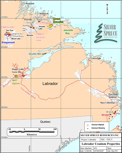
Silver Spruce owns a 100% interest in 942 claims (236 km2) in 5 uranium properties in Labrador. They include - Snegamook (86), Double Mer (74), Straits (397), Mount Benedict (377) and Jeanette Bay (8). The company also retains a 2% net smelter return (NSR) on the Central Mineral Belt Joint Venture (CMBJV) properties after dilution by continued exploration and expenditures by Crosshair Energy (Crosshair), the operator. Uranium mineralization has also been located on the 100% owned (optioned), road accessible, MRT property along the Trans Labrador Highway just west of Goose Bay.
CMBJV Project - The Two Time (TT) U deposit, located on the CMB northwest property has an NI 43-101 indicated resource of 2.33 M lb. (1.82 MT at 0.058% U3O8) and an additional inferred resource of 3.73 M lb. (3.16 MT at 0.053% U3O8). The zone remains open along strike and at depth and Crosshair has announced that it will continue exploration in 2012 to the south towards our Snegamook property. The Firestone Showing, located 7 km to the southeast of the TT Zone, gave 3.5m at 0.084% U3O8, including 0.5m of 0.519% U3O8 (DDH FS-11-007) in limited drilling. Other U showings, which will also be further evaluated by Crosshair in 2012, include the Jacques Lake and Northeast properties (see attached map for locations).
"The 2% NSR on the CMBJV properties means that Silver Spruce will benefit from continued exploration on the TT zone and the other prospects in the JV area without any further expenditures. Crosshair's 2012 work should also enhance the prospectivity of our Snegamook property which lies along strike of the TT deposit," Dimmell adds.
Snegamook (SN) -- located in the western part of the Central Mineral Belt (CMB) the property hosts the Snegamook zone, on strike to the south of the TT zone and the Near Miss prospect. Seventeen (17) drill holes on the Snegamook zone intersected a 20-50m wide zone of U bearing, brecciated/altered monzodiorite over a strike length of 300m, to a vertical depth of 200m, the same geological setting as the TT Zone. The zones are shallow dipping and vary in width from 5-53m, with grades ranging from 225 to 771 ppm (0.023-0.077%) U3O8. . The widest section in SN-08-8 averages 206 ppm U308 ((0.021% - 0.41 lb/ton) over 73m, similar to values located in early drilling on the TT zone. The Near Miss zone gives erratic U mineralization in hematized, brecciated, granitic to monzodioritic units with one meter intervals grading from 113-2,117 ppm (0.011-0.21%) U308 with the widest intersection averaging 213 ppm U308 (0.021%, 0.43 lb./ton) over 16m, including 1m at 0.21% (4.23 lb./ton) U308. Crosshair's drilling on the TT is within a few hundred metres of the northern boundary of the SN property, indicating the potential for the TT zone to continue onto the SN property at depth. Further exploration is warranted along the TT-Snegamook trend and in other prospects such as the Near Miss.
Mount Benedict (MB) -- Located in the eastern part of the CMB, the property has two significant U prospects, in the northern area of the property, the AT-649 and the T Super 7 zones.
AT-649 - Five representative grab samples, averaging 0.497% U3O8, define a high grade U zone at least 10m wide and exposed in a small brook flowing into Stag Bay. Float boulders downstream from the showing give values from 0.06 to 3.37% U3O8, with three values >1%. The host rock is a moderately to strongly hematized felsic to mafic intrusive which is fractured and veined with uraninite/pitchblende and magnetite. The high grade zone has not been tested directly due to environmental regulations which require a 50m set back from the brook. Nearby, diamond drilling (1,262.9m in nine holes) has defined a zone of low grade mineralization hosted in sheared and altered monzonite to monzodiorite. The zone varies from 4 to 16m wide, giving U308 values of up to 598 ppm (0.06%, 1.2 lb./ton) over 1m and intersections of 4.3m at 0.025% at a vertical depth of 40m.The zone was tested along a strike for 150m and to a vertical depth of 75m and remains open along strike and at depth.
T Super 7 - Located 4.8 km to the southwest of AT-649, it carries U mineralization in bedrock with values from 500 ppm (0.05%) to over 1% (20 lb/ton) U308. Tested by seven holes totalling 968 m, the drilling indicated weak to moderate mineralization over good widths. Mineralization in DDH MBS7-08-5 is hosted in a northeast trending mylonite zone which carries two separate mineralized zones: 27m (5-32m) at 138 ppm (0.014%) U308 and 22m (44-66m) at 278 ppm (0.028%) U308 in a highly altered felsic intrusive or volcanic unit. An 8m wide, higher grade section, from 51 to 59m grades 444 ppm (0.044%) U308. Geological mapping indicates a minimum strike length of 300m, remaining open along strike to the northeast and southwest. Radon gas surveys give strong anomalies over a minimum 750m strike length coincident with the zone. The mineralization is developed along a major northeast trending structure which trends through, and is associated with, the AT-649 mineralization. Further work, including diamond drilling, is warranted along this trend.
Double Mer -- Located on the north side of Lake Melville, the property is characterized by a linear, 10 km long airborne radiometric anomaly. It hosts two styles of U mineralization: 1) pegmatite-hosted and 2) structurally controlled in brecciated and/or mylonitized zones in polydeformed gneisses. Early stage prospecting (grab rock samples) located seventy-six (76) values >500 ppm (0.05%) U3O8 with forty-two (42) >1,000 ppm (0.1%), seven over the 95th percentile of 2,200 ppm (0.22%) and a high of 4,281 ppm (0.43%) U3O8. Uranium in soil values up to 208 ppm (bg <10 ppm) and radon gas anomalies occur over the mineralization, over widths up to 30m mainly in areas associated with short, steep scarps characterized by breccia units. Mineralization also occurs in a highly deformed pegmatite up to 40m, but generally 5-10m wide which can be traced over a minimum strike length of 300m. No follow-up trenching or drilling has been carried out.
Straits - The property, in the south Labrador coast area, hosts two significant U showings plus a number of prospects. The BB Shot gives values up to 67,439 ppm (6.7%) U3O8 in outcrop along the contact between a weakly gneissic, fine-grained granite and a pegmatite unit. The Bingo, approximately 3 km away, is associated with the contact between a granite and an orthogneiss, and gives 17 anomalous values (>10 ppm U3O8), with a high value of 5,887 ppm (0.58 %) U3O8. Mineralized zones are narrow, to a maximum of 1-2 m, but are generally 1 m or less. No follow up has been carried out.
MRT - This property is located just to the north of the Trans Labrador Highway, 35 km to the west of Goose Bay. Originally staked for its rare earth element (REE) potential, the property has yielded significant U values with limited U exploration. Three outcrop samples gave values of 0.825%, 0.027% and 0.088% U3O8. Seven prospecting grab samples, taken in the same general area during exploration for REE mineralization in the summer of 2011, gave values > 0.059% U3O8, including four >0.12 % U3O8. The samples were acquired in the southern part of the property along a 2 km trend not generally coincident with the high REE values. The U potential of this road accessible area clearly deserves follow-up work.
This release has been approved by Peter M. Dimmell, P.Geo., President and CEO of Silver Spruce Resources Inc., who is a Qualified Person (QP) in both NL and ON as defined in National Instrument 43-101.
About Silver Spruce Resources Inc.
Silver Spruce is a diversified junior exploration company with a portfolio of gold silver [Big Easy (with drilling planned in the near future)], rare earth [Pope's Hill, Pope's Hill JV (with Great Western Minerals Group), MRT, RWM and the Straits], and for the longer term, uranium [Snegamook, Double Mer, Mount Benedict, Straits, MRT, CMBJV] projects in Newfoundland and Labrador. With interests in more than 4,000 claims totalling more than 1,000 square kilometres in Labrador, Silver Spruce is one of the largest landholders in one of the world's premier emerging rare earth and uranium districts. For additional information please visit the company's website - www.silverspruceresources.com.
Neither TSX Venture Exchange nor its Regulation Services Provider (as that term is defined in the policies of the TSX Venture Exchange) accepts responsibility for the adequacy or accuracy of this release. The company seeks Safe Harbour.
For further information contact:
Gordon Barnhill, CFO & Director
Silver Spruce Resources Inc.
Phone: 902.527.5700
Fax: 902.527.5711
For investor & media relations contact:
Paul Snow
Pilot Communications Inc.
Phone: 709.753.0794 ext 31
Fax: 709.753.0795